2/15/2023 - Upper Falling Rock Hollow Waterfalls (WF)
GPS Coordinates: (Latitude, Longitude, Elevation)
Parking Area: 35.69786, -94.00663
WF 1: 35.69639, -94.00840
Rock Formation 1: 35.68980, -94.00835
Boulder At Top Falls : 35.69002, -94.00753
Cascade 1: 35.68954, -94.00778
Cascade 2: 35.68840, -94.00875
WF 3: 35.68808, -94.00928
Falling Rock Hollow Falls: 35.68832, -94.00876
Cascade 3: 35.68790, -94.00887
Rock Formation 2: 35.68346, -94.01025
Rock Formation 3: 35.68340, -94.01023
WF 5: 35.68329, -94.01025
Mossy Bluff Falls: 35.68331, -94.01011
Cascade 4: 35.68226, -94.00986
WF 7: 35.68058, -94.01132
Cascade 5: 35.68015, -94.00601
Cascade 6: 35.68150, -94.00419
Blossom Falls : 35.68470, -94.00118
WF 9: 35.68442, -94.00105
Cascade 7: 35.68443, -94.00095
Cascade 8: 35.68509, -94.00122
Cascade 9: 35.68579, -94.00118
WF 10: 35.68687, -94.00193
WF 11: 35.68635, -94.00127
Cascade 10: 35.68641, -94.00109
WF 12: 35.68746, -94.00066
WF 13: 35.68949, -94.00023
Cascade 11: 35.69018, -94.00018
Cascade 12: 35.69234, -94.99958
WF 14: 35.69292, -94.99955
Markers
Car Symbol = Parking area
Blue Waypoints = Named waterfalls
Black Waypoints = Unnamed waterfalls
Orange Waypoints = Cascades
Running Person Symbol = Access points
Backpacker Symbol = Gravel Road and atv trail
Stone Symbol = Rock formations
Level of Difficulty: The hike starts off easy along a gravel road. When you take a left and start bushwhacking, it becomes moderate. You will be hiking along mostly level terrain for awhile but you will be going through brush that is about waist high. The hills to get down into the hollow are strenuous. Once you are down in the hollow and work your way downstream, it is mostly moderate except when you have to go downhill to be in front of the bigger waterfalls. It is mostly moderate along the hollow while working your way upstream along a drainage of the hollow. You will eventually reach the last waterfall and then have to work your way back up to the top which will be strenuous.
Hiking Statistics for Loop: 4.40 miles / Highest to Lowest Elevation Difference: 998 ft
From the parking area, I hiked along the gravel road that is closed with a gate in front of it for a ways. A little ways, I could hear water running to my right so I went to check it out and that is where WF 1 is. I took some photo's and then headed back up to the closed gravel road and then took a right onto it and kept hiking. I eventually took a left and started bushwhacking from the gravel road at 35.69390, -94.01127 towards the hollow. You will be going through brush but it is only like waist high. It looked like a controlled burn had been done there by the National Forest Service. I hiked at an angle where I was working my way to the left and towards the hollow. I eventually reached where I needed to go down the steep hill to get in the hollow. The coordinates to where I went down are 35.68991, -94.00855 and I provided an access symbol on the map. I came across this nice rock formation to my right as I worked my way down the hill. After I was done there, I kept working my way down hill to my left to reach the 1st of the waterfalls, which is Boulder At Top Falls. I went behind the falls to look at the bluffs on the other side and then worked my way down in front of the waterfall. There was nothing special along those bluffs so I could have kept just going downhill to the bottom of the waterfall on the side I first came down. The water was not running as well as I was hoping that it would be but it was running decent. After I took many photo's, I started heading downstream along the hollow. I came across another cascade a ways down. After I took a couple of photo's of that, I continued heading downstream. I then came to another cascade but could see that this one was just above a big drop off . I got down below the cascade and above Falling Rock Hollow falls to take photo's and a video. I then climbed back up from being in between and worked my way along the hillside on my right side from top of the waterfall. I took my time and was careful. I'd seen another waterfall on my left as I was working my way along the hillside and that a drainage was leading to the top of that waterfall. I could see that there was a hill in a distance to use to get down below the waterfall if I stayed up above the falls and crossed the drainage and kept going. I decided to see if there was a way down to get below before I came to the top of waterfall 3 so I went to the edge and found a way that I could climb down that had a few steps to use. I took a photo of it and marked it. The coordinates of where I went down to get below waterfall 3 are 35.68811, -94.00924. When I got down, waterfall 3 was just to my right. I took some photos and marked it. It would be running even better than it was if it had rained like it did the week before. When I was done there, I headed along the bluff to get back over to where I was below and in front of Falling Rock Hollow Falls. I spent a lot of time taking photos there. When I was done, I continued downstream and came across cascade 3 a little ways down. Then a ways downstream from that, I came across an atv trail. I marked it on my gps at 35.68468, -94.00976 and then kept heading downstream. I eventually could see this neat rock formation up to my right at an angle so I headed uphill a little at an angle to reach them at 35.68340, -94.01023. There is a waterfall there also after heavy rain. By the rock formation, I was up by the upper level of that waterfall, which is waterfall 5. I could see that there was another level or 2 below of that waterfall. Because water was not running great, I was able to get down the wet and slippery rocks to get myself down to the lowest level of waterfall 5. If you are out there when water is running real good, you will have to probably go along the bluffs a ways more to find a better way to get down to where I got. After I got down, I took some photo's of waterfall 5 from below and then headed to my left along the bluff to get over to Mossy Bluff Falls. I took a break at Mossy Bluff Falls and took many photos and some videos. After my break was over, I headed downstream and came across cascade 4. After I took a couple of photo's, I kept heading downstream. Eventually, I'd seen a drainage to my right and decided to hike up on the hill along it to go see if a waterfall was there, which is waterfall 7. After I was done there, I headed back to the main hollow and then took a right to continue heading downstream. I could see to my left that I was almost down to the drainage that I was planning to head up. It is a nice level area and a good place to take a break at the intersection of the two so I took a lunch break there. There is nice scenery there also. When I was done with my lunch break, I backtracked just a little to find a good place to cross the creek to get over to the drainage on the left that I was planning to hike up to get back to the top and the road. As I was hiking, I came across cascades 5 & 6. I took some photos and then kept heading upstream. A ways later up the drainage, I could see a waterfall to my right and straight ahead. I could see that I could get above the falls at the one to my right so I went straight to Blossom Falls. I took many photo's and videos and then headed over to the other waterfall, which is waterfall #9. I spent some time there and then got myself above it on the left of the falls. It was a little climb there. Above it is cascade #7 which is very nice and has 2 parts. I stood between the 2 parts and took photo's. Then I went up on the hill and hiked along the hillside to get to the top of Blossom falls. I then headed upstream in the drainage and came across cases 8 & 9. After leaving those, I could see 2 small waterfalls ahead of me. One to the left and one to the right. One is waterfall 11 and the other is cascade 10. When I got to the one on the left, I could see another taller waterfall in the distance that lead to waterfall 11 so I hiked up to that one, which is waterfall 10. When I was done there, I went back below waterfall 11 and took photo's. I then went over to Cascade 10 and took photos. I then got up above cascade 10 and kept hiking upstream. As I was hiking I'd seen another small waterfall in the distance to my right. I was running out of daylight so I didn't hike all the way up to it. I kept hiking upstream and then reached waterfall 13. I took some photo's and then headed upstream again and came across another cascade, which is cascade #11. After that, I thought there would be no more waterfalls or cascades so I headed up to the left some and ended up on an atv trail. I was hoping it would lead me back to the road but in curved and crossed the drainage so I had to turn left and continue up the drainage. As I worked my way up the drainage, I came across waterfall #14 on my left. When I was done there, I hiked up the hill to the right of it and felt that it was time to start working my way up the hill back to the road since I was pretty much at the tip of the drainage. I worked my way up at an angle where I was going uphill but also to the right towards the road for a ways. I then seen a hill to my left that I felt that I could get up so I went straight up beginning at coordinates 35.69461, -94.00037. After I got up[ the steepest part, I then start hiking ant an angle again where I was going uphill but also working my way to the right towards the road. I eventually got up to where the terrain was just about level and took a right where I was on an atv trail at coordinates and then I hiked on that straight out to the road. I then took a left onto the gravel road and hiked that back to my car. I could have hiked more straight up and gotten onto the atv trail sooner than I did but did not know that it was there.
 |
| Boulder At Top Falls |
 |
| Mossy Bluff Falls |
 |
| Rock Formation 2 |
 |
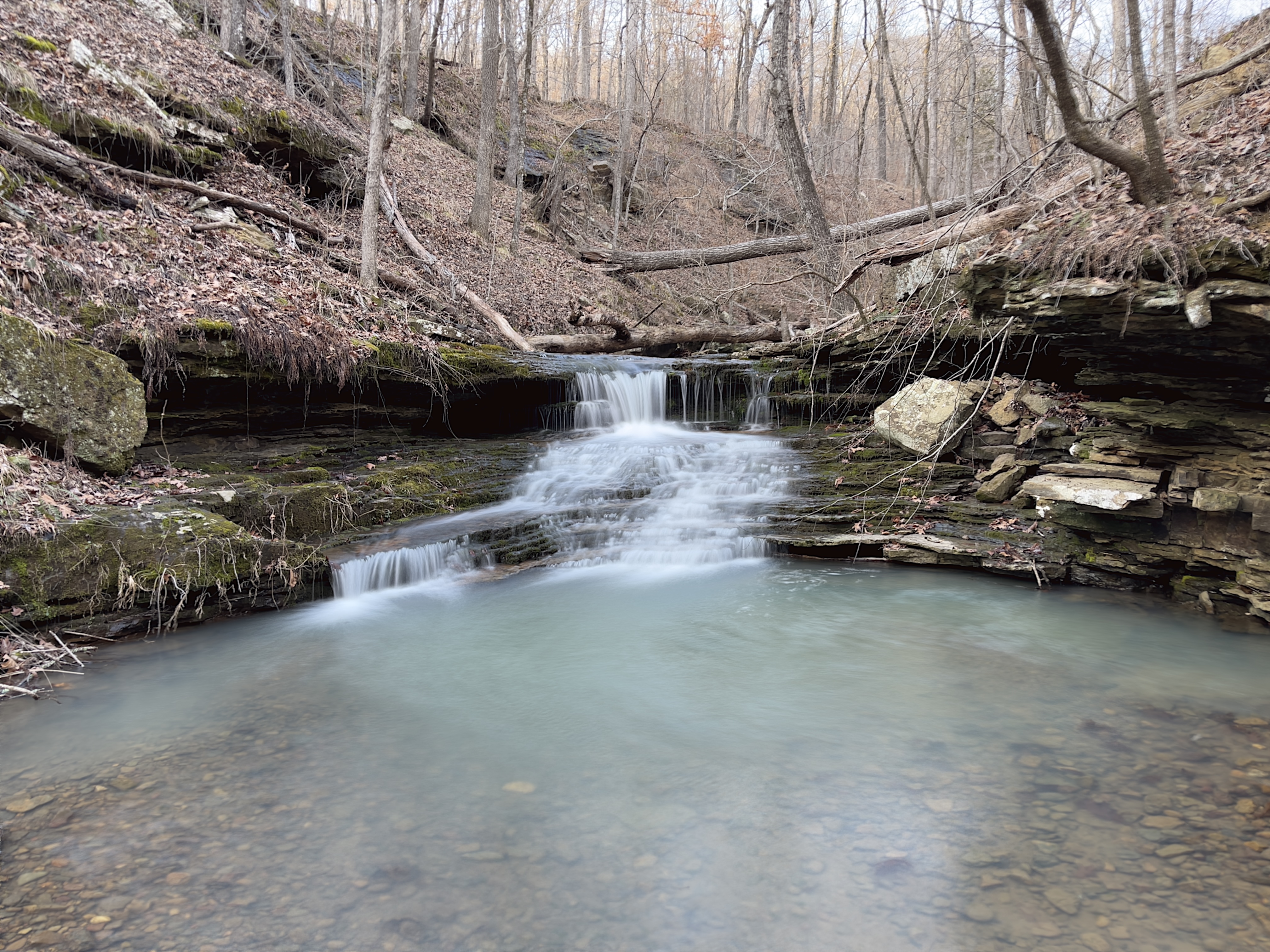
| Falling Rock Hollow Falls |
 |
| Blossom Falls |
 |
| Rock Formation 1 |
 |
| cascade 4 |
 |
| WF 9 |
 |
| cascade 7 |
 |
| Upper part of cascade 7 |
 |
| WF 10 |
 |
| WF 11 |
 |
| cascade 8 |
 |
| cascade 10 |
 |
| WF 13 |
 |
| WF 14 |

 |
| Parking Area |
 |
| My track |
 |
| Track with waypoints |
 |
| Part of track with waypoints |
 |
| Part of track with waypoints |
 |
| Part of track with waypoints |
 |
| Part of track with waypoints |


Cool place.
ReplyDelete