4/28/2020 - Eldridge Hollow Waterfalls (WF)
GPS Coordinates: (Latitude, Longitude, Elevation)
Parking Area: 35.73786, -93.55982
Cascade 1: 35.74166, -93.55407
WF 1: 35.74171, -93.55417
WF 2: 35.74181, -93.55422
WF 3: 35.74174, -93.55510
WF 4: 35.74153, -93.55519
Ferris Falls: 35.74171, -93.55542
WF 6: 35.74206, -93.55617
Tall Falls: 35.74223, -93.55625
Cascade 2: 35.74341, -93.55759
Cascade 3: 35.74370, -93.55856
Cascade 4: 35.74375, -93.55876
Cascade 5: 35.74404, -93.55904
Cascade 6: 35.74534, -93.56038
Cascade 7: 35.74579, -93.56136
Cascade 8: 35.74584, -93.56148
Cascade 9: 35.74575, -93.56199
Emblen Falls: 35.74622, -93.56434
WF 9: 35.74643, -93.56444
Cascade 10: 35.74648, -93.56456
WF 10: 35.74666, -93.56498
WF 11: 35.74702, -93.56538
Cascade 11: 35.74723, -93.56571
Glenna's Curve Slide: 35.74734, -93.56609
WF 12: 35.74757, -93.56617
Cascade 12: 35.74773, -93.56607
Rock Pile Falls: 35.74788, -93.56606
WF 14: 35.74739, -93.56640
WF 15: 35.74745, -93.56707
WF 16: 35.74782, -93.56953
Waylen Falls: 35.74844, -93.57017
Eldridge Boulder Slot Falls: 35.74851, -93.57105
Cascade 13: 35.74854, -93.57147
WF 19: 35.74851, -93.57224
The Slot area: 35.74859, -93.57228
WF 20: 35.74861, -93.57242
Cascade 14: 35.74862, -93.57242
WF 21: 35.74908, -93.57319
WF 22: 35.74895, -93.57345
Cascade 15: 35.74905, -93.57381
WF 23: 35.74905, -93.57437
WF 24: 35.74909, -93.57558
WF 25: 35.74913, -93.57314
WF 26: 35.74873, -93.57014
Directional Change Falls: 35.74887, -93.57002
Directional Change Falls: 35.74887, -93.57002
Cascade 16: 35.74599, -93.55940
Cascade 17: 35.74714, -93.55804
Cascade 18: 35.74865, -93.55457
Cascade 19: 35.74893, -93.55447
Cascade 20: 35.74963, -93.55209
Cascade 21: 35.74956, -93.55182
Cascade 22: 35.74945, -93.55155
WF 28: 35.74904, -93.55092
WF 29: 35.74900, -93.55072
Split Falls: 35.74873, -93.55034
WF 31: 35.74888, -93.55031
Eldridge Fern Falls: 35.74988, -93.55060
Upper Eldridge Hollow Falls: 35.75209, -93.54993
Eldridge Hollow Falls: 35.75198, -93.54995
Eldridge Double Tier Falls: 35.75198, -93.55013
WF 36: 35.75293, -93.55151
Tucked Away Falls: 35.75264, -93.55148
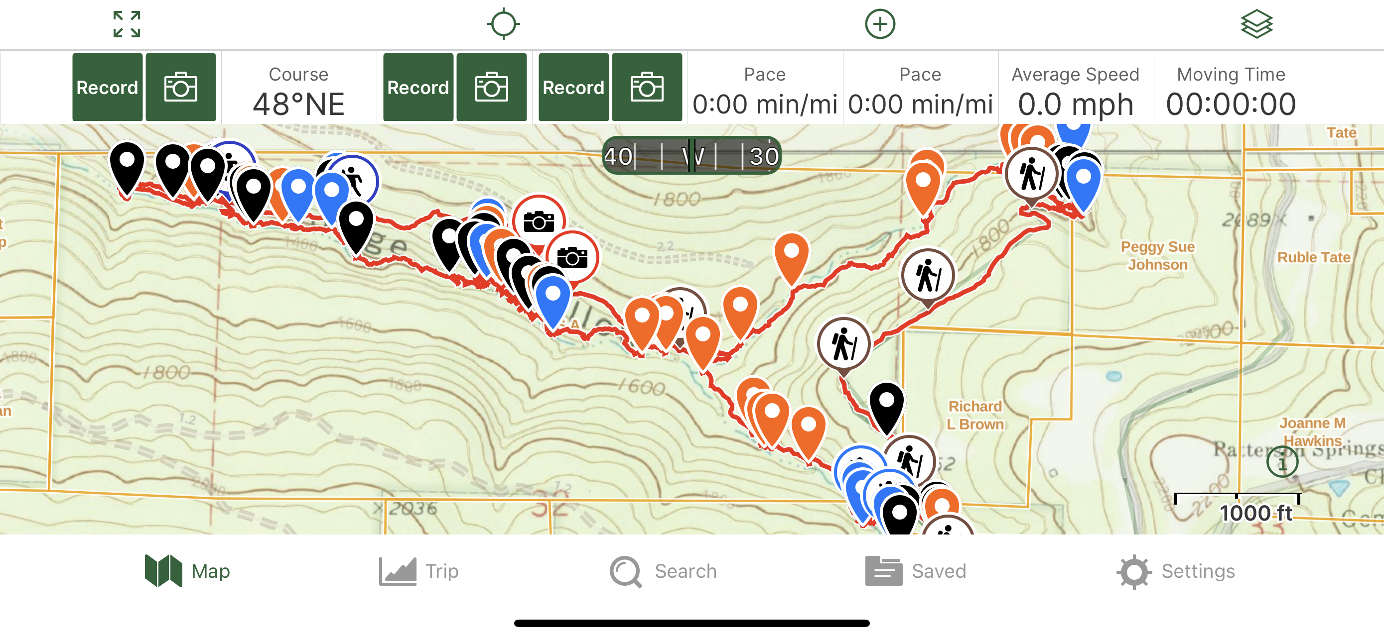
Markers
Blue Waypoint = Named WF
Black Waypoint = Unnamed WF
Orange Waypoint = Cascade
Hiker symbol = Ozark Highlands Trail
Running Person symbol = Access point
Car symbol = Parking area
Camera symbol - Old Atv trail
Level of Difficulty: Hiking along the OHT is easy to moderate. Hiking down the hills and into the hollow is moderate at first but then the hills become steeper to where the hike is strenuous. More than half of this hike is a bushwhack / off trail hike. While hiking in the upper part of the hollow, I had to climb over many downed tree's or go up and down hills to get around them which made the hike more strenuous. After I reached the fork, the hills were more gradual and then the terrain was level for awhile but I had to cross the water a good amount of times if I didn't want to have to hike up hill and then back down. On the way back and hiking up the other part of the hollow was moderate until I took the right tun to start working my way back up to the OHT. The hills to get to that trail and the waterfalls along it can be strenuous.
Hiking Statistics of Loop: 6.57 miles / The Ascent is 928 feet and the Descent is 913 feet
I had been here once before back in 2020. My friend Glenna joined me to explore the area. Multiple people have the upper part of Eldridge Hollow documented but I wanted to check out the lower part also so she joined me for the adventure. I drove to the town of Oark. Just a little east of that is the gravel road that I turned onto and drove along heading north to where I could either stay on that road or take a slight right. The OHT crosses both gravel roads. I stayed on that road and drove to where the OHT crosses it at the coordinates I provided for the parking area. I hiked along the OHT down to the hollow and decided to go the same way I did the first time where I would start bushwhacking where the hollow is first by the trail coming from the gravel road I parked on. I got off the OHT and started bushwhacking at coordinates 35.74107, -93.55393. I was in the hollow at coordinates 35.74151, -93.5541 and I quickly came across a nice cascade before reaching 2 unnamed waterfalls that Rick Henry and others had documented. I stopped at those and took photo's and marked them on my gps. The waterfalls were running very good after all the rain we had received that week. After I was done at those 2, a little ways down the hollow, I reached WF's 3 & 4. I took a stop there to get photo's and then continued on. The hills were moderate at times and a little steep at times at this point. There were tree's down like many other places where I either had to climb over them or hike up and down hills to get around them. I soon came to the top of the 5th WF named Ferris Falls. I hiked up the hill to my right from the top of the falls and found a hill to get down at coordinates 35.74195, -93.55545 to be down in front of Ferris Falls. I took a short break there while I was taking photo's and a video as well as marking it on my gps. It was running better than my first time there back in 2020. About 15 mins later, I was ready to continue on with the hike. As I was hiking down the hollow, I knew Tall Falls was coming up soon but forgot that there was another WF before it up to the left. When I'd seen that, I went up to it and took some photo's. It was running some but not as much as the others were. I then went back to the main hollow and then turned left and could see that I was going to be coming to the top of Tall Falls in just a little ways. When I reached the top of Tall Falls, I looked at my gps to see which hillside I used the first time there to get down the hill and in front of Tall Falls. I used the hill to my right from the top of the falls so I hiked up that hill and then along the hillside to coordinates 35.74245, -93.55621 and then I used that hill to get down below the bluff and in front of Tall Falls. It was running very good. I spent some time there before moving on down the hollow. I then came across 4 nice cascades before reaching the fork in the hollow. I knew to my right is the way I was going to be going back up to the other WF's in the upper part and to the OHT after I hiked down to all the WF's in the lower part of the hollow. I went up that some just to find a good place to cross the water. After I crossed, I took a left and headed back to the main hollow. I then took the right to continue heading down stream towards the lower part of Eldridge hollow. I came across 3 nice cascades in the hollow before reaching Emblen Falls. The water was running better this time than my first time so I did not cross it to be on the left side like I did my first time. There is a boulder there above it to the left that I was standing on while video taping during my first trip there. I just stayed on the right side this time because that is the side where we got down below it and in front of the falls the first time. I took a video facing it from up high while taking many photo's from many different angles before working my way down. There are like steps in the rocks on the right side that you can climb down and back up to get photo's from many angles but you can't climb all the way down unless you want to be in the pool of water and soaked. After I took many photo's, I climbed back up to the top and looked at my gps to see which hill I used to get down below the falls the first time. I worked my way to coordinates 35.74635, -93.56433 and used that hill to get down below. The water was running more this time so I knew that I was going to get my feet wet and it would be harder this time to avoid the water. There is a small WF to the right there when you get down but I just worked my way over to the left and in front of Emblen Falls. To get over to the right of it like I did the first time, I had to just walk through the water. I did that and took many photo's and a video. Then I crossed back over and went to that small WF and took some photo's of that and marked it on my gps like I did of Emblen Falls. After Emblen falls, you are between bluffs on both sides so water is coming off those, especially on the right side where I was hiking down along the hollow like Glenna and I did the first time. We were able to walk along narrow rock close to the bluff the first time and avoid walking in the water that time. I had to walk in the water at times this time with the water running more and at times, I was able to avoid being in it. There is a nice cascade there when you first start hiking that part between the bluffs on both sides. I love this part being between the bluffs with water coming off them. I remember how much fun Glenna and I were having the first time there. As we kept hiking further down, we were saying that it just keeps getting better. I passed by 2 more WF's along the bluff on the right side that I was hiking along that run after heavy rain. I took some photo's of being in that area again. I then came across one more cascade before reaching Glenna's Curve Slide. This falls is beautiful. I remember how excited Glenna and I were when we first came upon it. It was at least Mid-April when Glenna and I hiked there and she was feeling hot so she wanted to get in the water at some time. We could see the big pool at the bottom of the curve slide. When we got down below the slide and in front of the pool. Glenna went for a swim. I took photo's of her in the water. I decided to name it after her. On this hike, I remembered that we were able to get down to different levels in front of the curve slide to the right of it from the top like at Emblen falls but we had to climb back up again because the big pool is right below there. I also remembered that we went along the hillside to the right to get down in front of Glenna's Curve Slide. I took many photo's again from all different angles and a couple of videos of the full Curve Slide before starting to work my way down in front of it at coordinates 35.74738, -93.56619. As I was getting close to the hill to work my way down, I seen a small WF and a bigger one further up the hill a little ways. I had forgotten about those from the first hike. I hiked up that drainage on my right to those before working my way down and in front of Glenna's Curve Slide. The bigger falls further up is called Rock Pile Falls. I took some photo's, a video and marked it on my gps before going down in front of Glenna's Curve Slide. We got our feet wet just a little getting in front of Glenna's Curve slide the first time but I just had to walk through a foot of water at least this time to be right in front of it. I couldn't get as far over to the right in front of it like the first time since the water was higher this time. I took some photo's from in front of it. I took a 15 min break there before walking through the water again to get back onto the right side of the hollow. As I was working my way down the hollow, I came across WF's 14, 15 and 16. I took photo's of all of them and marked them on my gps. I then had to cross the main hollow based on how the hills were so I did. I hiked along the left side for a ways and then I'd seen another nice WF on the other side. It was too nice not to get up right in front of it so I crossed the main hollow again to be right in front of it. The water was like a foot and a half deep there. This is Waylen Falls. There is a cascade and another falls above it but it is too hard to get up to them from the bottom and I knew that I would be up at that level when on my way back so after I was done at Waylen Falls, I crossed the water again to get back to the left side of the hollow. I remembered that another WF was coming up that was kind of neat but hard to be in front of because a big boulder is partly in front of it and the big pool there. When I got close, I could see that boulder and then remembered that I had to stand on top of that boulder to be close to the falls because of the big pool. The boulder being there makes it kind of like a slot falls so I named it Eldridge Boulder Slot Falls. I went and climbed up the boulder and took photo's and a video while standing on top of the boulder. After I was done, I climbed down and continued on down the hollow. While I was working my way down, I was thinking about the neat slot area down there with multiple WF's just to the side running into it from my first hike there. It is a cool area. I passed one other wide cascade in the hollow before reaching the slot area. I'm on the left side of the hollow like I was the first time when I was at the slot area and those 2 WF's are on the left side running into the slot so I was walking on wet and slippery rock in areas. This time with the water running more, the water was a little higher even walking along the slot on the rock from the falls running better. You can walk along the slot close up at different levels depending on how high the water is. I crossed the first of the 2 falls there and then was able to get lower along the slot area where the water was gushing through there. I took many photo's and multiple videos of that area like the first time as well as marking it on my gps this time. There is a big pool at the end that the water runs into. After I passed the big pool, I came across 2 more WF's on my right and one on my left. I crossed the creek to the right side to take photo's and to mark those WF's and then continued on. I crossed also because I knew that I was going to be hiking up the hills on that side on my way back. There was one other WF I remembered that I wanted to get to before I turned around and started working my way back to the fork in the upper part of the hollow. I knew that I was going to hike back a quicker way than hiking in the hollow and that way was to be up a few levels of the hills where the terrain was decently leveled like Glenna and I did the first time. I decided also that I would work my way back along the hollow to those 2 waterfalls that I had just passed on my right and then work my way up the hill from there. After thinking about all that, I continued on hiking down the hollow. I came across another wide cascade before a WF on the other side of the hollow. I debated about crossing to get in front of it but I just didn't want to so I took a photo of it and marked it from the right side of the creek. Then I continued working my way to that one other WF. That WF was on the other side also so I debated about it and decided not to so I took a photo from there. Then I thought about it again and said to myself, that I have to get up in front of it so I walked through the water again to get up in front of it. I took photo's and marked it on my gps and then headed back to the main hollow to cross the water and get back onto the other side again. I then looked at the time and started rushing back to those 2 WF's where I was going to start hiking up hill. I took a break after reaching those 2 WF's before heading up hill. I headed up hill at coordinates 35.74908, -93.57315. After I reached the level that I wanted to be at where I knew those 2 falls were above Waylen Falls, I hiked along the hillside to reach that drainage at coordinates 35.74873, -93.57014. I came to a nice cascade and then seen a nice size WF above it. This WF is called Directional Change Falls because of the way the water comes down off the bluff. It was running good. I took photo's and a video of it as well as marked it on my gps. After I was done there, I started heading further up hill at coordinates 35.74868, -93.56964 to reach more level terrain to hike along all the way back to the fork in the upper part of the hollow. When I reached a certain level, I was on a very old Atv trail. I followed that all the way back to the fork. It stays up at the level I was at just a little ways and then starts gradually heading down hill. It reaches where it's right along the water just a little ways before the fork. When I reached the fork, I took the left to head up that other part of upper Eldridge hollow. I passed by 4 cascades while working my way up that before I got to where I could have either kept going straight or taken a right up to the trail. The top of both ways I could have gone are close to the OHT with WF's along them. I chose to take the right, which was the quicker way to the trail. While working my way up, I came across 3 cascades before reaching 2 of the unnamed WF's. I took photo's of them and then continued up the hill to the trail. Soon, I was on the trail. I then looked at my gps to see where the other WF's that have been documented were marked on my gps. Split Falls is along that drainage I came up just a little ways up from the trail. I headed up to that falls to take photo's and a video. When I was done there, I headed back to the OHT. I then started hiking along the OHT in the direction away from the parking area to reach another couple of WF's that are just down the hill a very little ways from the trail along another drainage. While I was hiking along the trail, I passed by Eldridge Fern falls which was just to my right along the trail. I stopped there for a few minutes and then continued heading on to those other WF's. When I got close to that drainage, I got off the trail and headed down hill to be below and in front of Eldridge Hollow Falls. I took some photo's and a video and then went just a little ways to the left where Eldridge Double Tier Falls is. I took photo's and a video of that before working my way up the hill that I had come down and to where I was just above Eldridge Hollow Falls. There, I was in the middle of Upper Eldridge Hollow Falls and Eldridge Hollow Falls. I took some photo's and a video before working my way back up to the trail. After I was back on the trail, I looked at the time it was and seen that I didn't have time to go to Tucked Away Falls and an unnamed WF above it. I provided the coordinates to them. I didn't get to see them the first time with Glenna being too tired and wanting to get out of there and this time, me not having the time with me needing to do another hike that day and cover another area to get onto the blog. I then hiked along the trail all the way back to the gravel road that I parked on.
 |
| Glenna's Curve Slide |
 |
| Emblen Falls |
 |
| Tall Falls |
 |
| Rock Pile Falls |
 |
| WF 14 |
 |
| Eldridge Boulder Slot Falls |
 |
| Directional Change Falls |
 |
| Ferris Falls |
 |
| Eldridge Double Tier Falls |
 |
| Upper Eldridge Hollow Falls |
 |
| Waylen Falls |
 |
| Split Falls |
 |
| Lower Eldridge Hollow Falls |
 |
| WF 6 |
 |
| OHT sign by gravel road |
 |
| OHT |
 |
| OHT |
 |
| My Track |


 |
| The slot area and WF |
 |
| The Slot Area |


Good work Jeff!
ReplyDeleteThank you
DeleteWhen we get to go back to Arkansas this is gonna be at the top of our list to do. Thank you for your blog!
ReplyDeleteYour welcome. I like sharing these places with other nature and waterfall lovers here in Arkansas
Delete