3/5/2023 - Nolan Hollow Waterfalls (WF) - On Google Earth also
GPS Coordinates: (latitude, Longitude, Elevation)
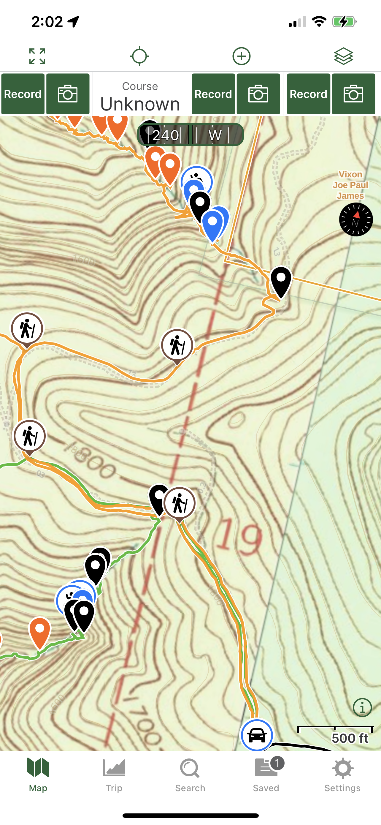
Parking area: 35.76213, -93.37467
WF 1: 35.77016, -93.37638
Salus Falls: 35.77097, -93.37802
Encounter Falls: 35.77086, -93.37813
WF 4: 35.77115, -93.37849
Nolan Hollow Shelter Falls: 35.77133, -93.37868
Nolan Hollow Cascade: 35.77170, -93.37932
Cascade 2: 35.77177, -93.37966
WF 6: 35.77219, -93.37992
Cascade 3: 35.77227, -93.38067
Cascade 4: 35.77231, -93.38103
Cascade 5: 35.77233, -93.38165
Cascade 6: 35.77240, -93.38206
Cascade 7: 35.77274, -93.38267
WF 7: 35.77334, -93.38326
Cascade 8: 35.77360, -93.38381
Cascade 9: 35.77366, -93.38392
Cascade 10: 35.77408, -93.38429
Cascade 11: 35.77448, -93.38526
Cascade 12: 35.77486, -93.38559
Cascade 13: 35.77513, -93.38679
Cascade 14: 35.77559, -93.38751
Cascade 15: 35.77591, -93.38772
Cascade 16: 35.77602, -93.38793
Markers
Blue Waypoint = Named WF
Black Waypoint = Unnamed WF
Orange Waypoint = Cascade
Hiker Symbol = Gravel road & ATV trail
Running Person Symbol = Access point
Car Symbol = Parking area
Level of Difficulty: Hiking along the atv trail at the beginning and at the end is easy. Hiking down Nolan Hollow is strenuous with the steep hills as well as having to work my way around downed tree's and having to climb over downed tree's. Hiking uphill from near the bottom of the hollow starts off moderate and then I hit a group of contour lines where the hills are steep which made that part strenuous. After I got up that set of hills, I hiked up a set of more moderate hills. After I was up those, I reached the toughest part where a group of contour lines are very close to one another which makes this strenuous and the steepest set of hills that I had to get up. After I got up that set, then the hills were moderate and gradual the rest of the way to the atv trail.
Hiking Statistics for Loop: 3.61 miles / Ascent is 682 feet and Descent is 689 feet
The parking area is the same as it was for Willis Creek. I was taking a break and eating in my car after the Willis Creek hike for 30 mins before I was ready to hike down Nolan Hollow. I hiked along the same atv trail that I did to explore Willis Creek but I went past both drainages that I went down and came up while exploring Willis Creek. I hiked along it until I reached Nolan Hollow. Right after the hollow along the atv trail is a gate with a private property sign. I started hiking down the hollow on the left side to keep off the private property. Very quickly, I could see that I was at the top of WF 1. I went down the hill to the left of it to get down below it. I took some photo's and then continued on hiking down the hollow. Staying in the hollow, I was inside just the corner of the private property. To get around it, you will need to go back up the hill from WF 1 and hike the hillside just a little ways to a small drainage and then follow that down to the top of Encounter Falls. You will be past the private property there and you will see that from the map I provide regarding the private property. There is another WF next to it about the same size. During my hike, I stayed in the hollow some and then went up the hill to my left to get off the private property and just a little ways down where the drainage met Nolan Hollow, I was at the top of Encounter Falls. I found a hill to the left of the falls to get down below the falls from the drainage. After I took photo's and a video of Encounter falls, I worked my way over to the right and into Nolan Hollow. When I got over to the hollow and looked upstream, I could see Salus Falls just a little ways upstream. I went up to it and took photo's and marked it on my gps. After I was done there, I continued hiking downstream in the hollow. I had to work my way over and around downed tree's while hiking down this hollow. I had to hike up and down hills while working my way down the hollow also. A little ways down from those 2 WF's, I came across WF 4. I took some photo's and then continued on down the hollow. I could see at a certain point that I would be at the top of another waterfall. When I reached the top, I could see that this one was taller than the other 2. I looked at both hillsides from the top of the falls and could see a possible way down on the right side. I then hiked up the hill on the right a ways and then along the hillside until I reached that hill to get down that I'd seen while standing at the top of the falls. I started heading down hill at coordinates 35.77151, -93.37866. I worked my way down at an angle to where I was below the bluff and right next to it. I hiked along side the bluff to where I was under the shelter there and on the side of the falls from a distance. Nolan Hollow Shelter Falls has a very nice and big shelter. I spent a long time there taking photo's from all angles of the WF and the shelter. I marked it on my gps and took a couple of videos. I decided to take a 10 min break there also to just sit and enjoy the waterfall. When I was ready to move on, I continued hiking down the hollow and then reach Nolan Hollow cascade. It is a tall cascade. I wish it was running better but it was running some. I took some photo's and then continued hiking. I then came across a smaller cascade before reaching WF 6 to my right. When I was done taking photo's there, I continue hiking down the hollow and came across 5 more cascades. I marked them all on my gps and then next I reached WF 7 in the main hollow. I spent some time there taking photo's and marking it on my gps. When I was done there, I continued on and came across 8 more cascades. After I made my way past all those, I could see that I was just about all the way down to Willis Creek. There is another smaller hollow over to the left of Nolan Hollow so I thought about cutting over to it and hiking up that to get back to the atv trail. I decided with it getting later in the evening and wanting to be back to my car before dark as well as my body getting tired with this being my second hike of the day, to just start working my way up the hills and back to the atv trail. I started working my way up the hill to my left at coordinates 35.77598, -93.38799. When I got up high enough to where I was at where the hills went up gradually to my left, I was at coordinates 35.77584, -93.38833. There are 2 sets of steep hills and 2 sets of gradual hills here while working your way up. From the last coordinates I provided, I worked my way up the hills to the first set of steep hills. I looked at how the contour lines were on my gps and just tried to go the easiest way up based on those. After I got myself up those to the first set of gradual hills, I was at coordinates 35.77361, -93.38665. I took a break there. I then kept working my way up the hills based on how the contour lines are on my gps to go the easiest way possible. I eventually reached the second set of steep hills and these are even more strenuous than the first set of steep hills. I started working my way up and went over to the right some to get myself up that set of hills. After I made it up those, I was at coordinates 35.76934, -93.38508. I took another break before moving on. When I was ready to move on, I just kept working my way up the hills based on how the hills are. These hills now are gradual and they are like that the rest of the way to the atv trail. I eventually reached the atv trail at coordinates 35.76829, -93.38159. I took a right onto the atv trail and hiked along that all the way back to the parking area. My body had enough now after the 2 hikes and was ready to go home and relax.
 |
| Nolan Hollow Shelter Falls |
 |
| Encounter Falls |
 |
| Salus Falls |
 |
| WF 1 |
 |
| Nolan Hollow Cascade |
 |
| WF 4 |
 |
| Cascade 7 |
 |
| WF 7 |
 |
| Cascade |
 |
| Cascade 8 |


 |
| Cascade 13 |
 |
| Cascade 13 |
 |
| Cascade 16 |
 |
| Shelter of Nolan Hollow Shelter Falls |
 |
| Shelter of Nolan Hollow Shelter Falls |
 |
| Parking area |
 |
| ATV Trail |
 |
| Terrain after I got up the steepest set of hills |
 |
| My Track |
 |
| Track with Waypoints |
 |
| ATV trail and part of hollow |
 |
| Upper part of Nolan Hollow |
 |
| Part of Nolan Hollow |
 |
| Lower part of Nolan Hollow and first couple of sets of hills |
 |
| Nolan Hollow and the Hills to get back to atv trail |
 |
| Showing where private property is |
 |
| Track with Waypoints |


No comments:
Post a Comment