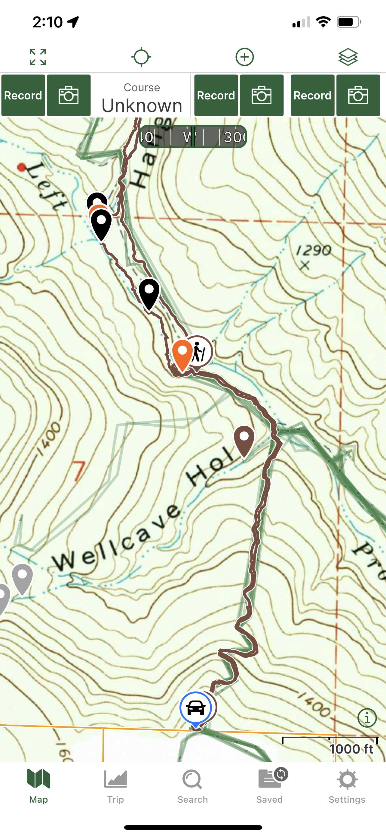
2/18/2023 Hanging Rock Hollow waterfalls (WF)
GPS Coordinates: (Latitude, Longitude)
Parking area: 35.71321, -93.79198
Mountain Fork Creek Falls: 35.72331, -93.79191
Cascade 1: 35.72321, -93.79244
WF 2: 35.72493, -93.79360
WF 3: 35.72688, -93.79526
Cascade 2: 35.72701, -93.79533
WF 4: 35.72735, -93.79541
Cascade 3: 35.73147, -93.79367
Overhang Shelter Falls: 35.73363, -93.79252
WF 6: 35.73367, -93.79123
Cascade 4: 35. 73388, -93.79142
Cascade 5: 35. 73416, -93.79128
Hanging Rock Hollow Falls: (6): 35. 73511, -93.79082
Cascade 6: 35.73527, -93.79065
Cascade 7: 35.73556, -93.79043
WF 7: 35.73707, -93.78785
WF 8: 35.73735, -93.78679
Cascade 8: 35.73754, -93.78713
WF 9: 35.73801, -93.78665
Cascade 9: 35.73934, -93.78588
Cascade 10: 35.74281, -93.78955
Trestle Falls: 35.74228, -93.78971
Landslide Lock Falls: 35.74168, -93.78992
WF 12: 35.74114, -93.79004
Cascade 11: 35.73629, -93.79088
Hanging Rock: 35.74875, -93.78363
Markers:
Blue Waypoint = Named waterfalls
Black Waypoint = Unnamed waterfalls
Orange Waypoint = Cascades
Car Symbol = Parking area
Running Person Symbol = Access points
Backpacker Symbol = Gravel roads and atv trails
Stone Symbol: = Rock formation
Camera Symbol = where the Ozark Highlands Trail is
Level of Difficulty: Hiking down the atv trail at the beginning of the hike is easy to moderate. Hiking along the main creek to the hollow is moderate if you stay by the creek. It is easier if you hike along the atv trail along the main creek. Crossing the creek can be challenging depending on how high the water is. Hiking up the hollow at the beginning is moderate mostly. Once you reach the fork and head one way, it becomes strenuous at times getting above the waterfalls. When you are working your way up the hills and along the hillside from that part over to the other part of the hollow, the hills will be strenuous. Getting down those hills back next to the water will be strenuous. Once you get back down to the main part of the hollow, the hike will become moderate again for the most part.
Hiking Statistics for loop: 7.40 miles / Maximum Elevation is 2,295 ft and Minimum Elevation is 945 ft with Ascent of 1,938 and Descent of 1,920
My friend and I parked on Mulberry Mountain Lodge's property off of Hwy 23. You have to pay $5 to park on their property. We parked at the coordinates I provided above for the hike. We hiked down the atv trail to the main creek, which is called Left Prong Mountain Creek. The atv trail does go to the left along the creek but we got off it to be in the creek to see Mtn Fork Creek Falls and to take photos of the waterfall and cascades. We hiked right along it on the left side until we got just past WF 2 and then we crossed over knowing Hanging Rock Hollow was on the other side of the main creek. We got our feet wet crossing that main creek. We then came across WF 3 in the main creek and cascade 2 to our right at the beginning of Hanging Rock hollow. We started hiking up the hollow and came across WF 4. After we took photos there, we worked our way up the hollow. A little ways up, we came across cascade 3. We then kept working our way up the hollow. Eventually we could see a nice size waterfalls to our left a little ways up a drainage. We started hiking up the drainage at coordinates 35.73344, -93.79242. When we reached Rock Head Shelter Falls, we could see that it was a nice size and had a shelter. The soil there under the shelter reminded me of the soil at Deer Trail falls in Tim Ernst's waterfall book. We spent some time there taking photo's and videos. When we were done there, we headed back to the main hollow and then took a left to continue hiking up the hollow. A little ways further up the hollow, we could see another waterfall on our right, which is WF 6. After we left WF 6, we passed by cascades 4 and 5 in the hollow. A ways up the hollow, we could see a tall waterfall up ahead and we approached the best and tallest waterfall we'd seen so far. This waterfall is Hanging Rock Hollow falls and it is a very nice waterfall. We took a break there for awhile as well as taking many photo's a videos. When we were done there, we had to backtrack a little to find a hill to the left of the falls to hike up to get to the top of it. We worked our way up the hill there and then hiked along the hillside and then down hill a little to get to the top of Hanging Rock Hollow falls. We didn't want to go too high up when working our way up to the top of the falls so we had to hike along the hillside for a little while before working our way downhill some. When we dropped back down into the hollow, we came across cascade 6. A little ways further up, we came to the fork in the hollow where we could either go up the west drainage or the east drainage of the hollow. We decided to hike up along the east drainage of the hollow and that we would work our way back down along the west drainage of the hollow and back to where they both join together. After we went to the right, we came across cascade 7. Hiking along the hollow is getting more tougher now with steeper hills and more trees being down. A ways up, we came across waterfall 7. We took some photo's and then continue on up the hollow. We then came across cascade 8. We could see a waterfall over to our right, which is WF 8. It was running some but not very good so I hiked only halfway up to it to mark it on my gps and get a couple of photo's. I then headed back down to the hollow and we then continued heading upstream in the hollow. We then came across WF 9 on our right. I took some photo's and then we headed upstream to cascade 9. After we reached that, I felt it was time to start working our way uphill at an angle to the right to get to Hanging Rock. So we started heading uphill at coordinates 35.73947, -93.78581. These hills are steep and strenuous. I knew Hanging Rock was close to Fly Gap road but didn't know how close. We kept slowly working our way up at an angle to where we were on some level terrain right in the middle of both parts of the hollow. We kept working our way up each hill one at a time and then taking a short break. We came across the Ozark Highlands Trail as we were working our way up the hills. We kept looking for bluffs and rock formations as we were working our way up each hill to some level terrain. We could not see any of that after we kept getting up each hill. We were finally at the top where it was level and before we knew it, we could see Fly Gap Rd. My friend waited up the hill and I went down the small hill to the road to see if I could see Hanging Rock. I eventually told him to come down and lets walk the road between the 2 parts of the hollow to see if we could find it. I didn't want to not find it after working that hard to get all the way up those hills and neither did my friend. We were hiking along the road and just past the part of the hollow to the left when we were down at the fork, we could see a jeep parked a little ways ahead of us and we thought that, that has to be where Hanging Rock is. Hanging Rock is a nice rock formation but not as good as some made it out to be to me. We got to it and took a lunch break up there. It was very windy up there. We took photo's and videos while eating lunch. We eventually were ready to get out of the wind and start the long hike back to his truck. We headed back on Fly Gap road towards where we came out onto the road when we worked our way up to it. We headed into the woods on the right a little earlier than where we came out. We tried to stay up and work our way down slowly along the hills in the center like we did getting up rather than getting down along the hillside on steep hills too early. We ended up going down a little earlier than we should have trying to find a way down at an angle to the right to reach the west drainage we planned to hike down back to the main hollow. Because we started hiking downhill to the right a little too early, we ended up having to walk a ways along some steep hillsides. These hills are steep and strenuous up at that level. We stayed at a certain level until we got to the better hills to get down at coordinates 35.74327, -93.78618 like the ones we used to hike up to the top. We came across another part of the Ozark Highlands Trail while working our way down the hills and into the drainage. We kept working our way slowly down the hills at an angle. We eventually finally got ourselves down into the west drainage. As we were working our way down the drainage, we came across cascade 10. We came across many trees down again like we did going up the east drainage while working our way down the drainage. A little ways down the drainage from there, we came to the top of a nice waterfall called Trestle Falls. We used the hill to our right from the top of the falls to get down to it at coordinates 35.74235, -93.78985. We spent some time there taking photo's and videos. When we were done there, we continued hiking down the drainage. We could see that some landslides took place there on the right side a little ways after Trestle Falls. Just a little ways down the drainage, we reached the top of another waterfall and could see that a landslide took place to the right of it. We used the hill to the left of the falls and headed down at coordinates 35.74166, -93.78979 to get down in front of Landslide Lock Falls. We took some photos there and then kept heading down the drainage. Not that far down, we reached the top of WF 12. We could see that another landslide took place by that falls to our right so we went along the hills to our left from the top of the falls. My friend stayed up on the hillside while I went down the hill at coordinates 35.74102, -93.78991 to where I was right in front of the waterfall. To get below all these waterfalls, you have to go uphill some first and hike along the hillside to find a hill to go down. I took photo's and debated about working my way along the right side of the drainage but could see that many trees were down. My friend suggested that I go back up to where he was and continue along the hillside and find a better place to get back down into the drainage so I went back up to where he was. We hiked along the hillside a little ways and found a better place to get back down into the drainage at coordinates 35.74019, -93.79022. We got back into the drainage and hiked a ways down it before coming across cascade 11. After we passed that, a little ways further, we were back at the fork and in the main hollow. We then hiked down in the hollow some and then decided to hike up the hill to our right and stay up there where we were hiking on decent level terrain to get back down to the main creek quicker since we already seen all the waterfalls and cascades in the main hollow while working our way up it. When we got back down to it, we got onto the atv trail that was on the side of the creek we were on. That atv trail goes along the main creek and then down to it close to the top of Mtn Fork Creek Falls. We hiked along that until it went down to the creek where it crosses the creek so we found a way to cross the creek. We got our feet wet again. We then got back onto the atv trail on the other side and hiked along that until it started going uphill to Mulberry Mountain Lodges property where we parked. We took a nice break before hiking uphill. After our break, we started hiking uphill along the atv trail. It was a hike up that hill along the atv trail. We eventually reached the top where the parking area is. We were tired after this hike. This was a long and strenuous hike.
My opinion after this hike is that Hanging Rock is not worth hiking up to from the bottom like we did. If you have a high clearance vehicle that can be driven on Fly Gap Rd, that is a much better and easier way to get to Hanging Rock since it is right along the road. If you want to hike to the waterfalls along Hanging Rock Hollow only and start where we did, I suggest just hike up to cascade 9 in the east drainage and then work your way uphill to coordinates 35.74096, -93.78747 and then over and downhill to cascade 10 in the west drainage. Then work your way down the drainage and all the way back to the parking area. That will be closer to a 5.75 mile roundtrip hike instead of a 7.40 mile roundtrip hike like we did. The elevation will be about 300 feet less also than what we did.
 |
| Hanging Rock Hollow Falls |
 |
| Trestle Falls |
 |
| Landslide Lock Falls |
 |
| Overhang Shelter Falls |
 |
| WF 6 |
 |
| Hanging Rock |
 |
| WF 3 |
 |
| Cascade 2 |
 |
| Cascade 5 |
 |
| WF 7 |
 |
| Cascade 1 |
 |
| Mtn Fork Creek Falls |
 |
| My Track |
 |
| Part of Track with Waypoints |
 |
| Part of Track with Waypoints |
 |
| Part of Track with Waypoints |
 |
| Track with Waypoints |
 |
| Parking area |
 |
| Trailhead |
 |
| ATV Trail |


No comments:
Post a Comment