2/11/22 - Lower Chinquapin Branch Waterfalls (WF) - On Google Earth also
GPS Coordinates: (Latitude, Longitude, Elevation)
Parking Area: 35.61534, -93. 59903
Cascade 1: 35.60941, -93.60693
Curve Bluff Falls: 35.60826, -93.60681
WF 1: 35.60762, -93.60683
Cascade 3: 35.60751, -93.60659
Cascade 4: 35.60722, -93.60659
Chinquapin Falls: 35.60698, -93.60651
Ortega Falls: 35.60623, -93.60648
WF 4: 35.60609, -93.60645
Cascade 5: 35.60483, -93.60627
Cascade 6: 35.60416, -93.60564
Cascade 7: 35.60412, -93.60568
WF 5: 35.60380, -93.60559
Cascade 8: 35.60363, -93.60558
Cascade 9: 35.60342, -93.60555
Creedence Falls: 35.60323, -93.60548
Drummonds Falls: 35.60287, -93.60305
Cascade 10: 35.59993, -93.60718
Cascade 11: 35.59975, -93.60724
Cascade 12: 35.59968, -93.60707
Cascade 13: 35.59952, -93.60778
Cascade 14: 35.59951, -93.60836
Florence Cascade: 35.59899, -93.60992
Cascade 16: 35.59815, -93.61298
Cascade 17: 35.59830, -93.61291
WF 8: 35.59762, -93.61414
Rock Formation 1: 35.59978, -93.61835
Vista 1: 35.59982, -93.61812
Rock Formation 2: 35.60018, -93.61761
Shelter 1: 35.60035, -93.61717
Vista 2: 35.60035, -93.61695
Rock Formation 3: 35.60064, -93.61670
Shelter 2: 35.60107, -93.61537
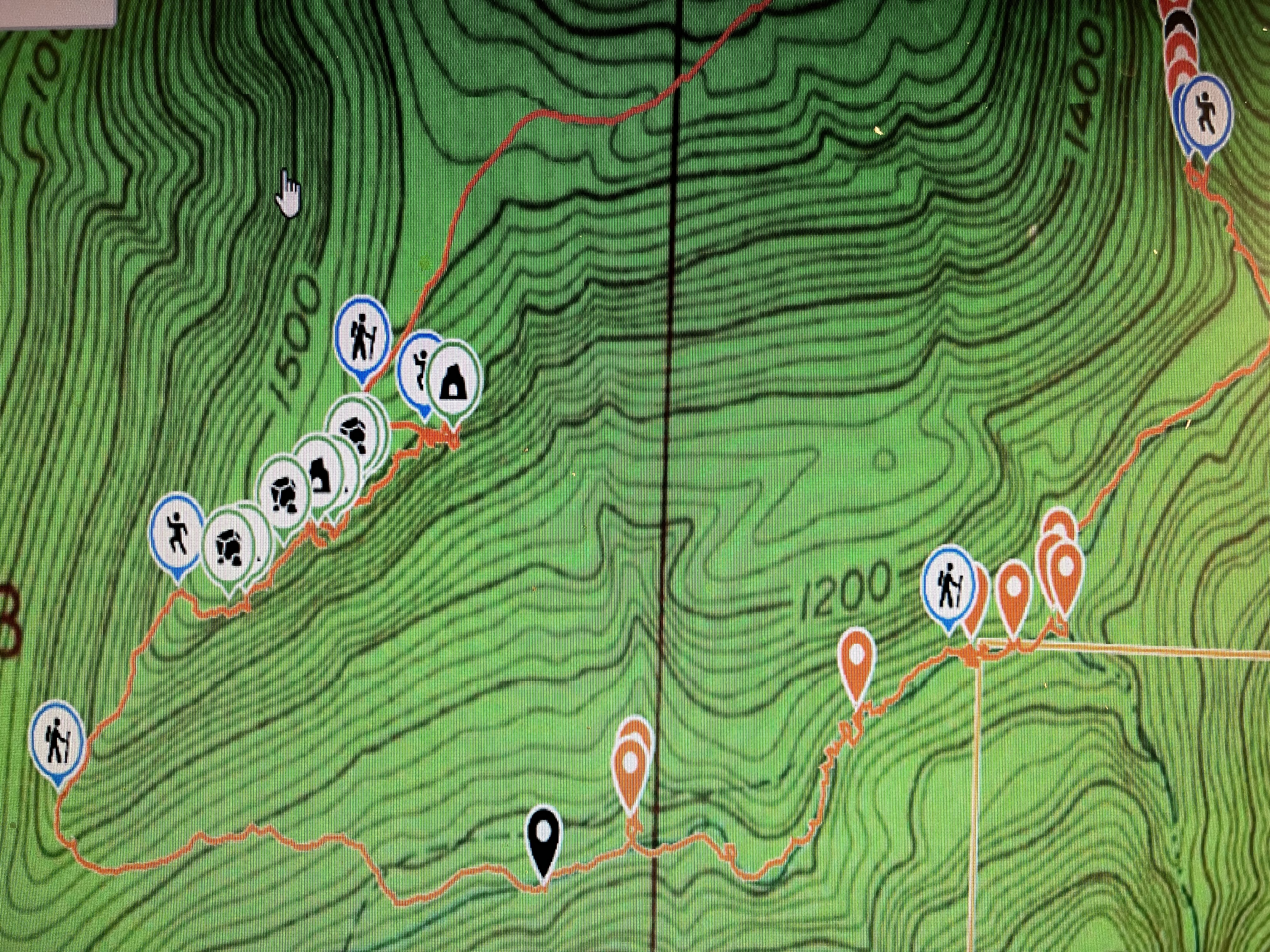
Markers
Blue Waypoints = Named Waterfalls and Cascades
Black Waypoints = Unnamed Waterfalls
Orange Waypoints: Unnamed Cascades
Backpacker = Where the gravel road and old atv roads are
Running Person = Access point
Stone symbol = Rock formation
Peak symbol = Vista
Shelter symbol = Shelter
Car symbol = Parking area
Level of Difficulty: The parts of the hike up high along the gravel road and down along the main branch where it's mostly level is moderate. The hills that you go down along the 2nd drainage are steep and strenuous. The hills that you use to get back up are not quite as steep but can still be strenuous.
Hiking Statistics for Loop: 5.83 miles / The Highest to Lowest Elevation difference is 892 ft
Chinquapin Branch is by the town of Batson and runs into Horsehead Creek. To get to the parking area, I take Hwy 103 either from I-40 from the south or Hwy 215 from the North. I then turn onto CR 4160 heading west off of Hwy 103 which is paved to the parking area which will be on the left. A photo of the parking area has been provided below. From the parking area, I headed down the gravel road. I'd seen another old gravel road to my left soon but knew I had to stay on the gravel road I was on in order to reach the big drainage that I wanted to go down and explore. You will see on your gps that there are 2 big drainages. The first drainage is for Upper Chinquapin Branch and that will be in another post. Once you get past the 1st big drainage as your hiking on the gravel road, you will see another rougher old road with a gate to your left where I have the backpacker symbol at 35.61163, -93.60554. I staid on the main gravel road that curves to the right to start right at the top of the drainage so I would not miss anything in the drainage but you can take that road instead of the main gravel road to get down the hill to the first waypoint I listed. I continued down the drainage to where I came to the top of Curve Bluff Falls. I used the hillside to the right of the waterfall to get below it. These hills are steep so I had to be careful working my way along the side to get down below. Curve Bluff Falls is nice and the way the rock formation is curved outward was interesting to me. After I was done taking photos there, I continued down the drainage and came across a small cascade. At the top of it, I'd seen to my right a small waterfall so I went up to it and took some photos. I then headed back down to the drainage and continued on to the next cascade I came across. As I was working my way down the drainage from that, I could hear the water running off and eventually see a good size drop off and knew it would be a good size waterfall. After I reached the top of Chinquapin Falls, I had to figure out which hillside would be best to get below the falls. I decided to use the hillside to the left as I'm at the top of the falls looking down. Once again, these hills and hillsides are steep so I had to be careful working my way along it. I provided an access point to where you can get down below the falls at 35.60671, -93.60627. I worked my way down and went along the bluff below to where I could see the waterfall to my left. It is a nice waterfall and I spent a decent amount of time there taking photos. I was then hoping I'd find even bigger ones there when I was working my way down the drainage from there. Soon I could here water falling that was a little louder. I soon reach the top of Ortega Falls. This one is a little taller. I decided again to use the hillside to my left to get down below the falls. The access point is at 35.60624, -93.60609 to start working your way down below the bluff and the waterfall. I worked my way down and then again stayed along the bluff as I worked my way to where I could see the waterfall to my left. Ortega falls is the tallest waterfall there. I again spent a lot of time there taking photos. To the left along the bluff from Ortega falls, another waterfall will be running after heavy rain. It wasn't running my first time there back in 2020 but was on Feb 11th of 2023 during my second time there. After I left Ortega falls and worked my way down the drainage, I came across 3 more cascades before reaching another waterfall. This was a small one but still nice and different. After I took my photos and headed on down the drainage, I came across 2 more cascades before reaching the top of another nice waterfall that's called Creedence Falls. I for the third time, used the hillside to the left to get down below Creedence Falls. The access point to get below is at 35.60316, -93.60523. Creedence falls is a nice waterfall and I spent a good amount of time there taking photo's. At this point, I was almost all the way down the drainage to the main Chinquapin Branch. After I was done there, I worked my way down into the main branch. I was planning to take a right into the main branch but could see a waterfall in the distance to my left so I headed to that first. That is where Drummonds Falls is. I took my lunch break there and enjoyed the falls and the area. After I was done with my lunch break and taking photos there, I headed downstream along the main branch. You go along pretty level terrain down along the main branch in parts. There are a good amount of crossings to prevent from going up and down hills in certain parts. You will come across cascade 10 and then another small one in the main branch. When I reached the second one, I could see another nice cascade to my left. I crossed the creek to go over to it and take photos. Then I crossed back over and reached a nice cascade that is cascade 13. From here on for awhile, I hiked on rocks that where sticking out from the ground along the sides of the creek. When I reached cascade 14, I climbed down the rock to get in between the small bluffs on both sides to be right in front of the cascade. It's very neat down there being right in the middle of the small bluffs next to the water. I took photos and then climbed back up to continue hiking downstream along there. I then came to the top of Florence Cascade. This is a very nice cascade to spend time next to and enjoy the area. I got down in front of it and took photos and then went back up near the top of it and took a break to enjoy the area. After I was done there, I continued heading downstream and eventually seen 2 cascades to my right so I hiked up to those and took photos. I had to go to the right to get above the first cascade to reach the second cascade. When I was done there, I continued heading downstream and seen one more small waterfall on the side. A little ways after I passed that, I started heading up steep and strenuous hills where I was going up to my left instead of going straight uphill. I could see an easier hill over to the left so I worked my way uphill at an angle until I reached that less steep hill. Once I reached that hill, I could see that I was on a very very old atv trail. I have that marked on my track. The coordinates for it are 35.59830, -93.62064. I followed that up until I reached the top of some bluffs and rock formations. I got off that and worked my way down below the bluffs at coordinates 35.59988, -93.61902. I provided an access symbol on my map for that. I went along the bluffs for a little while. There are some nice overlooks, rock formations and shelters along there. I eventually seen a way to get back up above the bluffs at coordinates 35.60113, -93.61574 but I wanted to go a little further to a second shelter. After I was done there, I backtracked a little ways to that access point and climbed up it. This is a climb so it's not for everyone. Where I went down to get below the bluffs is much easier. You could backtrack to where you first went down below them if that is better for you. You could also go further along the bluffs than I did. After I got up above the bluffs, I worked my way uphill to get back onto the gravel road that I began my hike on which is at coordinates 35.60139, -93.61657. I hiked on that gravel road all the way back to my car. If you decide to backtrack instead and go back up where you went down, get back onto that very old atv trail and that should take you too the gravel road and to where I got back onto the gravel road. Then hike on that all the way back to your vehicle like I did. This was a long hike and has steep hills. The hills that you go up are not quite as steep as the ones you go down to get to the bottom
 |
| Chinquapin Branch Cascade |
 |
| Chinquapin Falls |
 |
| Ortega Falls |
 |
| Creedence Falls |
 |
| Drummonds Falls |
 |
| Cascade 10 |
 |
| Cascade 13 |
 |
| Cascade 14 |
 |
| Florence Cascade |
 |
| v |
 |
| v |
 |
| v |
 |
| Vista 1 |
 |
| Shelter 1 |
 |
| Rock Formation |
 |
| Shelter 2 |
 |
| Parking area |
 |
| Gravel road |
 |
| Rougher road with gate |
 |
| My Track |
 |
| Track with Waypoints |
 |
| Parts of Track with waypoints |
 |
| Parts of Track with waypoints |


No comments:
Post a Comment