2/2/2023 - Upper Rock Creek Rock Formations and Waterfalls (WF) - On Google Earth also
GPS Coordinates: (Latitude, Longitude, Elevation)
Parking area: 35.73163, -93.24396
WF 1: 35.73370, -93.24023
WF 2: 35.73375, -93.24039
WF 3: 35.73386, -93.24047
Cascade 1: 35.73397, -93.24061
Cascade 2: 35.73421, -93.24085
Cascade 3: 35.73441, -93.24113
Cascade 4: 35.73489, -93.24134
Cascade 5: 35.73495, -93.24136
Cascade 6: 35.73512, -93.24130
WF 4: 35.73510, -93.24144
Cascade 7: 35.73517, -93.24151
WF 5: 35.73545, -93.24200
Cascade 8: 35.73655, -93.24472
Cascade 9: 35.73674, -93.24496
Cascade 10: 35.73680, -93.24512
Cascade 11: 35.73789, -93.24640
Cascade 12: 35.73913, -93.24771
WF 6: 35.73944, -93.24770
Cascade 13: 35.73961, -93.24684
WF 7: 35.73998, -93.24591
Cascade 14: 35.74048, -93.24512
-----------------------------------------------------------------------------------
Rock Formation 1: 35.74039, -93.24538
Feature 1: 35.74089, -93.24632
Feature 2: 35.74102, -93.24643
Feature 3: 35.74177, -93.24703
Rock Formation 2: 35.74217, -93.24734
Feature 4: 35.74226, -93.24738
Shelter 1: 35.74233, -93.24746
Shelter 2: 35.74227, -93.24765
Shelter 3: 35.74246, -93.24748
Rock Formation 3: 35.74270, -93.24801
Shelter 4: 35.74386, -93.24888
Shelter 5: 35.74394, -93.24867
Rock Formation 4: 35.74467, -93.24809
Shelter 6: 35.74484, -93.24795
Turtle Head Rock Formation 5: 35.74505, -93.24790
Feature 5: 35.74515, -93.24768
Feature 6: 35.74534, -93.24756
Feature 7: 35.74551, -93.24733
Rock Formation 6: 35.74567, -93.24736
Feature 8: 35.74564, -93.24719
Feature 9: 35.74556, -93.24722
Rock Formation 7: 35.74557, -93.24708
----------------------------------------------------------------------------------------
Ignoto Falls: 35.74520, -93.24511
Cascade 15: 35.74567, -93.24571
WF 9: 35.74601, -93.24617
Cascade 16: 35.74674, -93.24693
Feature 8: 35.74884, -93.24762
Cascade 17: 35.74950, -93.24749
Cascade 18: 35.75079, -93.24441
----------------------------------------------------------------------------------------
Cascade 19: 35.75088, -93.24325
Cascade 20: 35.75073, -93.24308
Cascade 21: 35.74999, -93.24035
WF 10: 35.74927, -93.23895
Cascade 22: 35.74687, -93.23603
Upper Rock Creek Falls 2: 35.74691, -93.23581
Upper Rock Creek Falls 1: 35.74688, -93.23571
WF 13: 35.74541, -93.23550
Bluff Line Falls: 35.74513, -93.23519
Cascade 23: 35.74504, -93.23495
Rock Creek Split Falls: 35.74498, -93.23455
WF 16: 35.74391, -93.23223
WF 17: 35.74397, -93.23221
Cascade 24: 35.74378, -93.23190
WF 18: 35.74378, -93.23170
------------------------------------------------------------------------------------------
Cascade 25: 35.75162, -93.23430
Cascade 26: 35.75175, -93.23560
Cascade 27: 35.75177, -93.23585
Cascade 28: 35.75169, -93.23658
Cascade 29: 35.75167, -93.23685
WF 19: 35.75156, -93.23710
Cascade 30: 35.75155, -93.23725
Cascade 31: 35.75149, -93.23913
Cascade 32: 35.75359, -93.24176
Cascade 33: 35.75433, -93.24102
WF 20: 35.75597, -93.23969
Delto Falls: 35.75911, -93.23658
---------------------------------------------------------------------------------------
Cascade 34: 35.76018, -93.23113
Cascade 35: 35.75990, -93.23103
Cascade 36: 35.75960, -93.23080
WF 22: 35.75930, -93.23071
Cascade 37: 35.75919, -93.23067
WF 23: 35.75907, -93.23051
Cascade 38: 35.75879, -93.23040
Cascade 39: 35.75848, -93.23020
Cascade 40: 35.75767, -93.22983
WF 24: 35.75690, -93.22922
WF 25: 35.75564, -93.22858
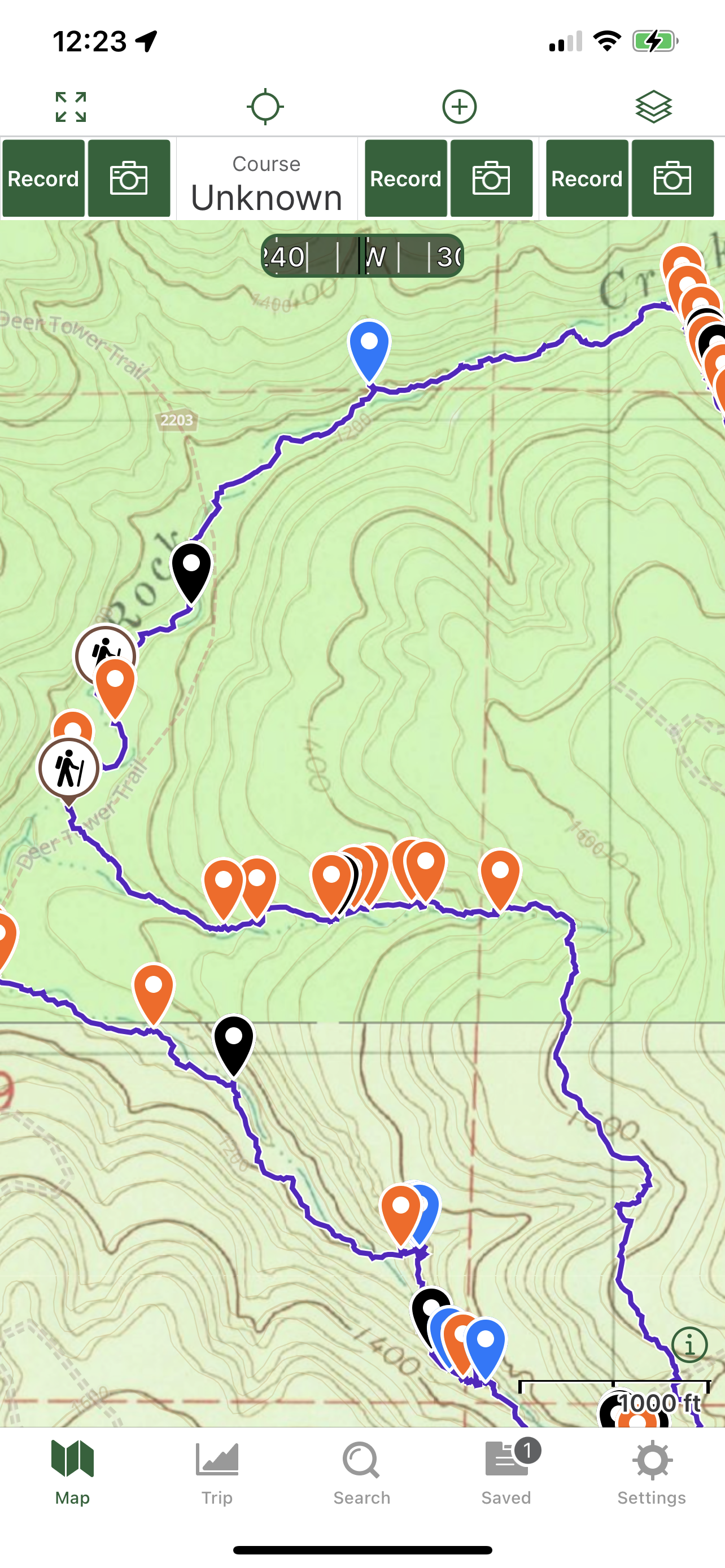
Markers
Blue Waypoint = Named WF
Black Waypoint = Unnamed WF
Orange Waypoint = Cascade
Stone symbol = Rock formation
Binoculars symbol = Feature
Sleep symbol = Shelter
Car symbol = Parking area
Hiker symbol = Old road
Running Person symbol = Access point
Level of Difficulty: Hiking along the atv trail up high and down along Rock Creek is easy. When bushwhacking along the main creek, it is moderate along it since it's mostly level terrain down there. The atv trail crosses Rock creek multiple times. The crosses are bigger along the creek than they are in the drainages. The hills along the upper parts of the hollows and drainages are steep but the hills along them in the lower half and closer to the creek are moderate. There are many downed tree's that you have to climb over or go up hills and down to get around in the drainages which makes the hike tougher. I had to cross the water in the drainages every time I didn't want to hike uphill and had the option to cross instead. The first hill I went down was moderate for the first half and then was strenuous when I got closer to the drainage. The hills I used to get out and back to the road were moderate at times where the hills were gradual and then some steep hills at times that made it strenuous at times.
Statistics of Loop: 9.62 miles / Ascent is 1,647 ft and Descent is 1,476
I drove to the town of Deer, which is along Hwy 16. I turned onto Parker Ridge rd, which is a gravel road and drove a ways on that to the parking area. I started hiking into the woods on the right since rock creek was to the right of the road from the parking area and tried to find the easiest hills to get down into the big drainage follow my gps. I planned on getting down right at the tip of the drainage but I ended up in it a little ways down so I hiked up the drainage to see if there was any wf's or cascades. Water was not running as good as I was hoping it would be. I ended up down by the drainage at coordinates 35.73440, -93.24125. I passed by 3 cascades before reaching 3 small wf's. I took photo's and marked them all and then turned around and started hiking down the drainage. I passed by where I originally came down and passed by 3 more cascades before I reached the next wf. I marked them all and took photo's. Tree's were down at times so I had to work my way over, under or around them at times. After I was done at the last wf, I came across another cascade and another WF while working my way down the drainage. By the next wf, I could see that there was an old road on the left side of the drainage heading down the drainage so I got on that and hiked along that. I was on that for a little awhile and came across 5 more cascades and a wf before I reached a small drainage on my right at coordinates 35.73913, -93.24771. I could see some neat rock formations up there so I crossed the big drainage and followed the small drainage up the hill. I came across 2 more wf's and cascades while working my way up before I left the drainage and started hiking along the bluff line and by the rock formations at coordinates 35.74046, -93.24529. I hiked along the bluff line and came across many rock formations, features and shelters. I spent time inside the shelters, taking photo's and marking all the features. I ended up following the bluff line all the way until the hillside came to the next drainage. I'd seen a nice waterfall coming off the bluff and into the drainage. This falls is Ignoto Falls. I took a snack break there and took many photo's and marked the falls. After I was done there, I looked at my gps and decided to hike down that drainage and back to Rock Creek. While working my way down the drainage, I came across 2 more cascades and wf 9. I ended up on another old road while working my way down that drainage. When I reached Rock Creek, I took a right and seen that the old road continued in the direction I was going so I hiked along since it went along the creek. I passed by a couple of wide cascades in rock creek while hiking along the old road. I eventually reached the big drainage on my right that I was planning to go up and explore. I took the right and it was wide at first and the hike up it wasn't bad for the first 3rd of the way up it. I came across 3 more cascades while working my way up the drainage before reaching wf 10. I took photo's and marked them all. The hills started getting steeper and the drainage was narrower past wf 10. I had to again go over, under and around downed tree's. I eventually reached this big bluff to my left that had water coming off of it in 2 parts. Water was coming off to the left and then water was coming off of it straight in front of me. Water was coming off more straight in front so I named that one Upper Rock Creek Falls 1 and the one to the left Upper Rock Creek Falls 2. I spent awhile there taking photo's and a lunch break. After I was done there, I continued hiking up the drainage. Thankfully this bluff was to the left of the drainage and not right in the middle of the drainage because then I would have had to find a way to get above it to continue up the drainage but I didn't have to do that. As I was working my way up the drainage, I came across wf 13 before reaching another big bluff to my right this time but this bluff was right along the water and curved with it. Again, water was coming off it in 2 places. I named the first falls Bluff Line Falls. I took some photo's of that and marked it. I then kept hiking by the water along the bluff and seen even a better wf up ahead coming off the bluff. Part of the bluff here is sticking out making the water coming off split into 2 parts so I named it Rock Creek Split Falls. I took photo's and marked it as as spending about 20 minutes there enjoying the area. The bluff curved around to the left so I did have to work my way up the hill to get above Rock Creek Split falls. After I got above it, I continued working my way up the drainage. The hills are getting even steeper now and the drainage is narrower. I came across 3 more wf's and another cascade before I looked at my gps. I'd seen where I was on my gps map and decided that it was time to cut over along the hillside to the next drainage that I was planning to hike down and back to Rock Creek. I started heading up hill at coordinates 35.74381, -93.23105 and the first few hills were steep but then they got more gradual up higher. I worked my way up and along the hills to coordinates 35.74776, -93.23176 and then seen on my gps that I could start heading down hill to the other drainage. The last couple of hills were steep getting down into the drainage. After I got down into the drainage, I started hiking downstream and came across 1 wf and 7 more cascades while working my way back down to Rock creek. There were downed tree's again that I had to deal with. The drainage got wider halfway down it. Once I reached Rock creek, I was back on the old road again and hiking along the creek. I passed by 2 more cascades and another wf before reaching Delto Falls on the left. I spent some time there taking photo's and marking it. When I was done there, I looked at my gps to see how much further I had to go to reach the drainage I was planning to hike up to get back up high and back to my vehicle. It was getting close to 5:00 pm at that time. I kept hiking along the old road by the creek until I reached the big drainage on my right that I had to hike up. While working my way up the drainage, I came across 7 more cascades and 4 more wf's. I took photo's and marked them all. The drainage got narrower half the way up it and the hills got steeper. I went a little ways further up the drainage past wf 25 and didn't see much more so I decided to start hiking up the hills and back to Parker Ridge Rd at coordinates 35.75386, -93.22818. I reached an old road while working my way up the hills at coordinates 35.75156, -93.22816 and hiked along that back to Parker Ridge Rd. I took a right onto Parker Ridge Rd when I reached it and hiked along it back to my vehicle. Hopefully water will be running better the next time I hike around this area.
 |
| Rock Creek Split Falls |

 |
| Upper Rock Creek Falls 1 |
 |
| Ignoto Falls |
 |
| Delto Falls |
 |
| WF 3 |
 |
| Upper Rock Creek Falls 2 |
 |
| Bluff Line Falls |

 |
| WF 16 |
 |
| WF 18 |


 |
| WF 5 |
 |
| Feature 2 |
 |
| Shelter 2 |
 |
| Feature |

 |
| Shelter 1 |
 |
| Shelter 3 |
 |
| Feature |
 |
| Shelter 5 |
 |
| Shelter 4 |
 |
| Feature |
 |
| Feature |
 |
| Shelter 6 |
 |
| Feature |
 |
| Feature |
 |
| Rock Formation |
 |
| Feature |
 |
| Rock Formation |
 |
| Feature |
 |
| Parker Ridge Rd Parking |
 |
| Old Road |


No comments:
Post a Comment