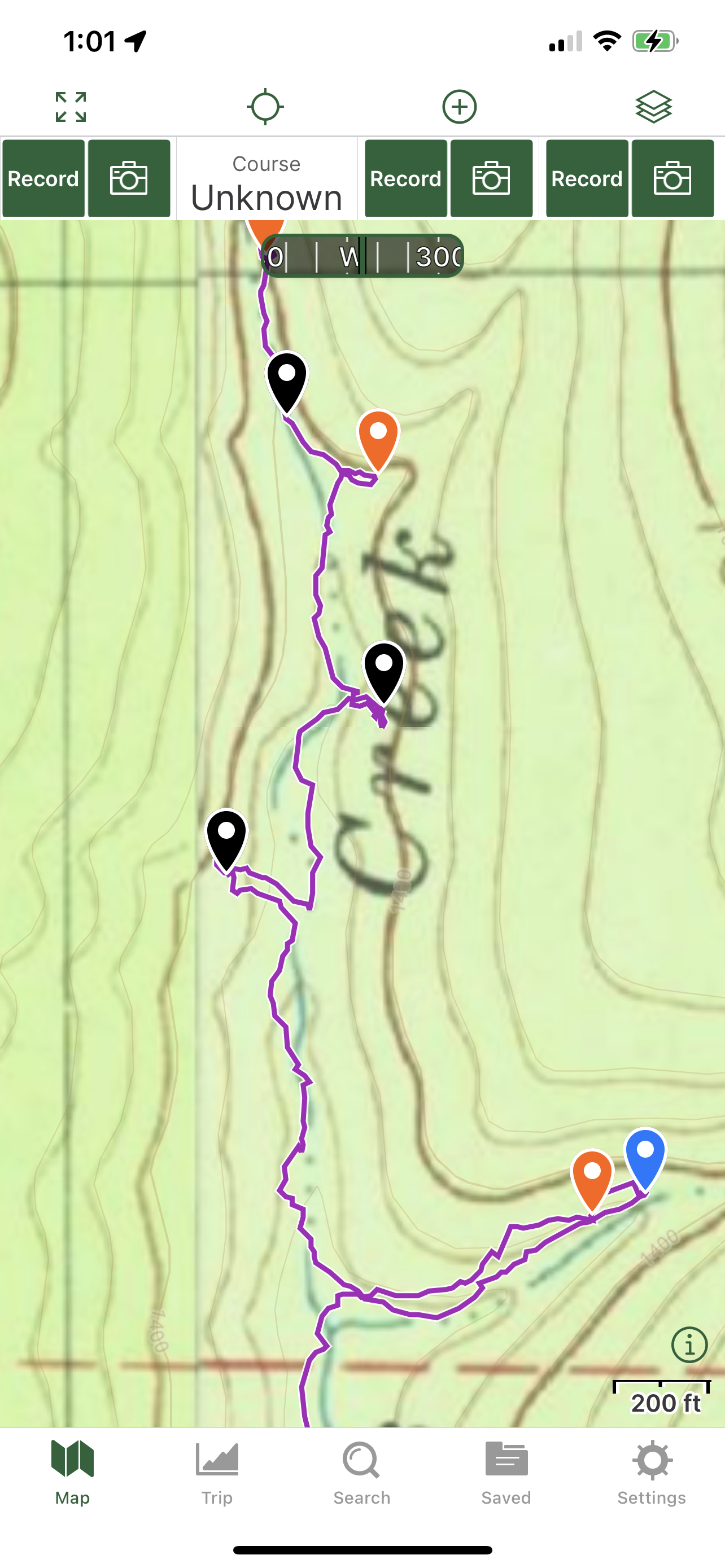
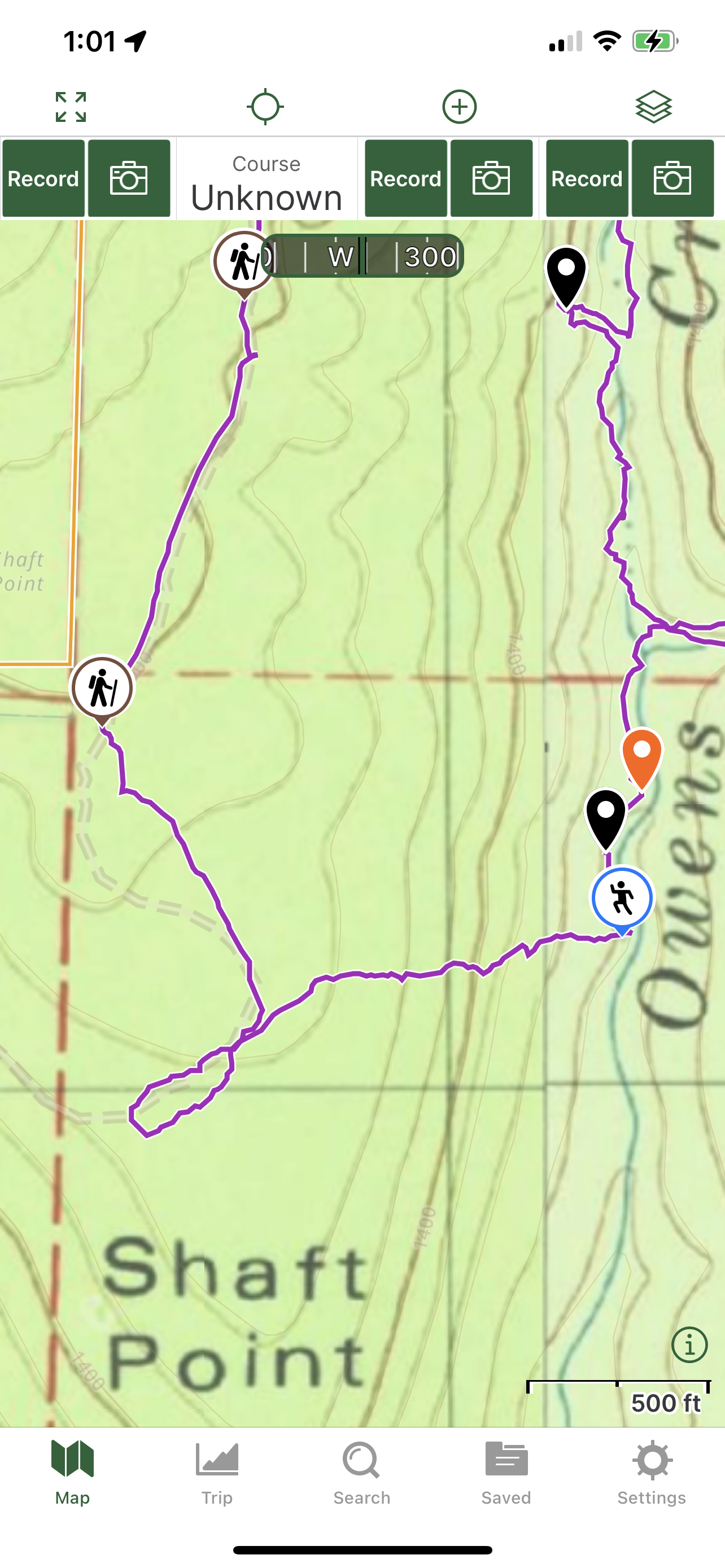
3/12/2023 - Owners Creek waterfalls (WF) - On Google Maps also
GPS Coordinates: (Latitude, Longitude, Elevation)
Parking area: 35.73121, -93.37700
Cascade 1: 35.72796, -93.37720
Cascade 2: 35.72780, -93.37709
WF 1: 35.72734, -93.37670
Cascade 3: 35.72675, -93.37640
Cascade 4: 35.72661, -93.37632
Owens Creek Falls: 35.72624, -93.37611
WF 3: 35.72602, -93.37627
Cascade 5: 35.72529, -93.37608
WF 4: 35.72485, -93.37634
WF 5: 35.72535, -93.37558
WF 6: 35.72492, -93.37592
Perel Falls: 35.72501, -93.37606
WF 8: 35.72403, -93.37556
Recall Falls: 35.72382, -93.37583
WF 10: 35.72319, -93.37518
Cascade 6: 35.72320, -93.37497
Cascade 7: 35.72237, -93.37474
WF 11: 35.72147, -93.37460
Cascade 8: 35.72115, -93.37397
WF 12: 35.71986, -93.37394
WF 13: 35.71893, -93.37501
Cascade 9: 35.71705, -93.37252
Flat Slab Falls: 35.71717, -93.37215
Cascade 10: 35.71538, -93.37432
WF 15: 35.71493, -93.37465
Markers
Blue Waypoint = Named WF
Black Waypoint = Unnamed WF
Orange Waypoint = Cascade
Brown Hiker symbol = ATV trail
Running Person symbol = Access point
Car symbol = Parking area
Level of Difficulty: Hiking along the atv trail is easy to moderate. Hiking down the creek at the beginning is strenuous with the steep hills to get down and then having to go up and down then to work my way along the creek and around the downed tree's was strenuous. There are a good amount of downed tree's that I had to climb over, go under or work my way up or down hills to get around them. While hiking up the drainage, there were more downed tree's that I had to work my way around so I had to hike up and down hills to get around them which was strenuous. Hiking up the hill to reach the atv trail was moderate at times and strenuous at times.
Hiking Statistics of Loop: 4.03 miles / Ascent is 580 feet and Descent is 626 feet
To get to the parking area, I drove on Hwy 21 south through the town of Salus to CR# 5570. I turned east onto that and drove to the parking area. There is an atv trail there to first hike along. I hiked along the atv trail a little ways down and then came to a fork. I could have staid on that atv trail that curves to the left or taken a sharp right onto another atv trail. I had to take the right to get closer to Owens Creek. My plan was to hike down the creek and then work my way up the hills on the right side back to the atv trail and hike along that all the way back since the atv trail went a good ways up high. I reached the creek at coordinates 35.72851, -93.37834. I started heading down the creek and came across 2 cascades first. I stopped and took some photo's of them. The hills here are more moderate than other places I've hiked at and explored. There were some but they were not steep when I was first working my way down the creek. I then came across WF 1 before 2 more cascades. I marked all those on my gps and took photo's of them. At this point, I'm starting to have to either climb over downed tree's or go up and down hills to get around them again. After I climbed over a couple while working my way down the creek, I reached the top of a taller WF, which is called Owens Creek Falls. I went along the hillside to the left from the top of the falls and used the hills at coordinates 35.72613, -93.37592 to get down below the bluff. I then worked my way to the right along the bluff to get in front of Owens Creek Falls. I took many photo's and a video as well as marked it on my gps so I spent like a good 20 mins there before moving on. As I was leaving the WF, I was looking at the bluff to my right and seen another WF so I hiked up to it to take a few photo's and mark it on my gps. After I was done there, I went back down to the creek and then continued heading downstream. I came across a cascade before seeing another WF coming off the bluff to my right from a distance. I hiked over to that and marked it. I then went back down into the creek and just a little past the cascade. I could see some boulders down and a bluff next to them on the other side of the creek so I decided to go check that out to see if there was anything to see over there. I got to where I was walking between a boulder and a bluff and seen another WF to my right coming off the bluff. I marked it and took some photo's before heading back down to Owens Creek. I decided to stay up along the bluff for a little bit and headed down to the creek at an angle. When I got down, I'd seen that there was another bluff I needed to get below because there was a WF in the main creek. I started working my way down the hill to get below the bluff at coordinates 35.72482, -93.37579. When I first got just below it, there was a WF coming off it so I marked it on my gps and took some photo's. I then kept working my way down into the creek and then took a right in the creek to head up to the falls in the main creek, which is called Perel Falls. I marked it as well as taking many photo's and a video. These WF's were not running as good as I would have liked them to be running but they were running some. After I was done there, I continued hiking down the creek. I soon reached the top of WF 8, which is a nice falls. I could see the bluff to my right at an angle from the top of WF 8 and see that a WF was coming off of it. I used the hills to the left from the top of WF 8 to get below and in front of it. I marked it and took photo's first and then headed up the hill to my right when facing down stream to the bluff and to the tall WF. Recall Falls is a good size falls in height and I decided to take a break there to eat something and drink some water. When I was finished taking my break and taking the photo's and video, I headed back down to the creek and continued hiking down the creek. I then came to a cascade in the creek and a falls to my right that wasn't running but would be after heavy rain. I marked both of them and then continued on. I was still having to climb over downed tree's as well as having to hike up and down hills to get around them, whichever way was better and easier. The creek is getting wider here and the terrain is more level on both sides of the creek than it was in the upper part. I passed by another cascade in the main creek before passing by 3 small drainages that one had a nice cascade and two had small WF's. Two drainages were on my left and one was on my right. I looked at my gps and at the time and knew that I was running out of daylight time but I was just about at a big drainage on the left that I had planned on hiking up a ways and exploring it. I soon took the left and started hiking up it. I passed by a cascade before reaching Flat Slab Falls. I took photo's and a video as well as marked it. I then looked at the time and knew that I had a ways to go after I got back down to the creek before I would reach the big drainage on the right that I had planned to hike all the way up and then get onto the atv trail that I was on earlier. So I decided to turn around and head back down to the creek. I took the left to continue hiking down the creek after I got back down to it. I was trying to move fast at this point with 6:00 pm approaching soon. I came across another cascade and another WF to my right while hiking in the creek. A little ways after those, I looked at the time and it was 6:00 pm. I knew that I still had to hike up those hills and find the atv trail and then hike that all the way back. I just didn't have time to continue hiking down the creek to the other big drainage on the right and hike up along that to get up the hills. I started hiking up the hills aiming for the atv trail at coordinates 35.71430, -93.37450. So I didn't get to explore 2 of the big drainages. The hills in the middle part of the hike up to the atv trail were the steepest. Getting up those was strenuous but then the last 4 were gradual hills. I was aiming for the atv trail on my gps but since the atv trail is not exactly like it showed on my gps, I ended up hiking in a small loop trying to find it at the top where the terrain was level. I started thinking to myself after I'd seen the loop I just made on my gps hiking, that it would be bad if I had to bushwhack most of the way back with it getting late. I then kept hiking up hill along the easiest ones at an angle to try and find the atv trail. I finally found the atv trail at coordinates 35.71586, -93.37923. I was very relieved after I was on it. I followed that all the way back to the fork where I could either take a left or a right. I took the left to get back up to the gravel road and my car. It was 7:16 pm when I got back to my car so I felt that I made the right decision to start heading uphill to the atv trail when I did. I'll have to go back some time to explore those 2 big drainages. You have the coordinates on exactly where the atv trail is so if you hike a similar rout, you know where the atv trail is.
 |
| Owens Creek Falls |
 |
| WF 1 |
 |
| Perel Falls |
 |
| WF 8 |
 |
| Recall Falls |
 |
| WF 13 |
 |
| Flat Slab Falls |
 |
| WF 5 |
 |
| WF 6 |
 |
| WF 12 |
 |
| Parking area |
 |
| the start of the atv trail from the gravel road |
 |
| The fork with the 2 atv trails |
 |
| Old atv trail where I got back onto it |


No comments:
Post a Comment