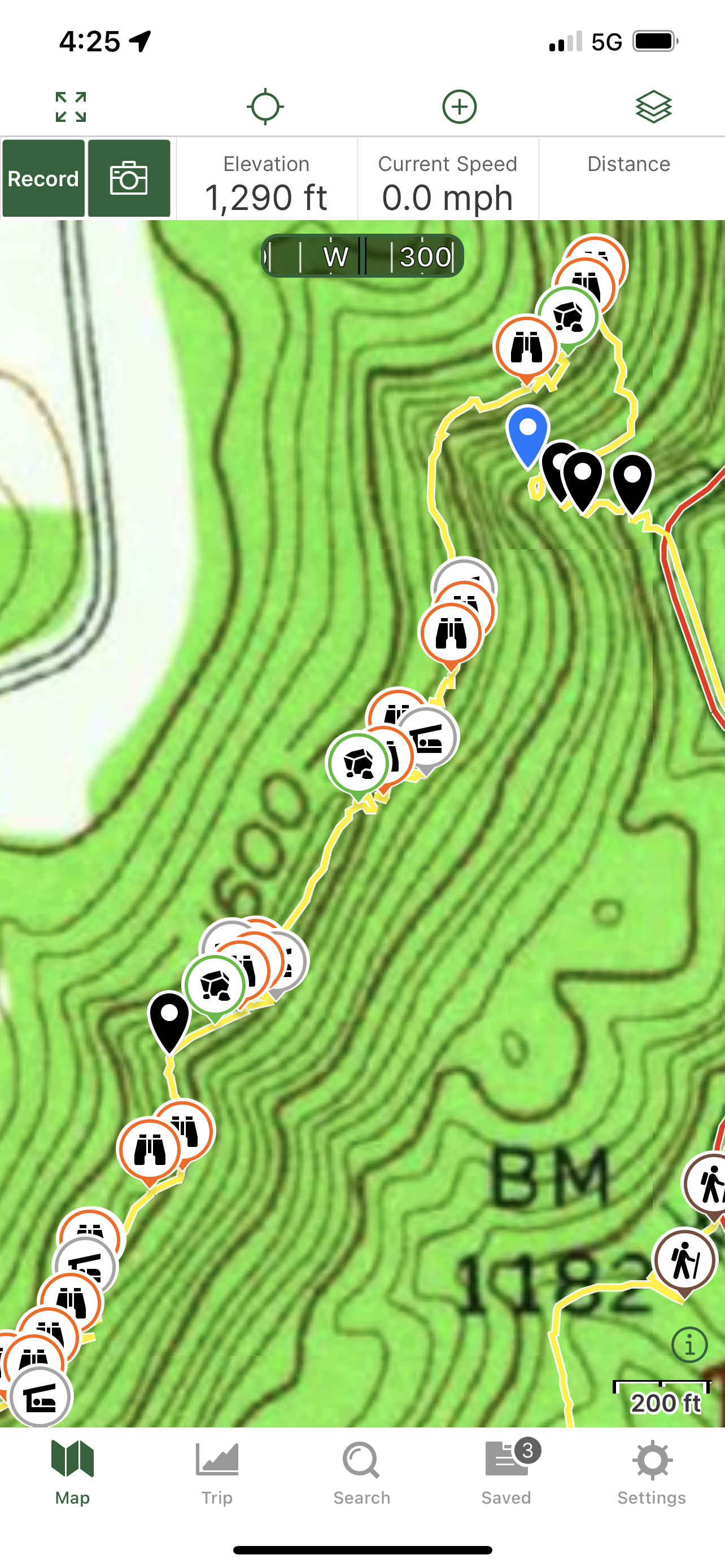
2/5/2023 - Chinquapin Ridge Bluffs (North)
GPS Coordinates: (Latitude, Longitude, Elevation)
Parking Area: 35.60267, -93.58623
ATV Trail: 35.59997, -93.58662
Rock Formation 1: 35.59683, -93.59278
Bluff Line: 35.59752, -93.59372
Shelter 1: 35.59785, -93.59249
Feature 1: 35.59802, -93.59246
Feature 2: 35.59800, -93.59235
Feature 3: 35.59811, -93.59213
Feature 4: 35.59814, -93.59217
Feature 5: 35.59821, -93.59204
Rock Formation 2: 35.59828, -93.59190
Shelter 2: 35.59831, -93.59192
Feature 6: 35.59832, -93.59191
WF 1: 35.59889, -93.59201
Feature 7: 35.59893, -93.59172
Feature 8: 35.59898, -93.59144
Feature 9: 35.59898, -93.59126
Feature 10: 35.59897, -93.59125
Shelter 3: 35.59879, -93.59121
Feature 11: 35.59912, -93.59115
Feature 12: 35.59931, -93.59100
Shelter 4: 35.59951, -93.59090
Feature 13: 35.59966, -93.59087
Feature 14: 35.60016, -93.59046
Feature 15: 35.60026, -93.59024
WF 2: 35.60090, -93.59033
Rock Formation 3: 35.60107, -93.59002
Feature 16: 35.60115, -93.58985
Rock Formation 4: 35.60115, -93.58984
Shelter 5: 35.60126, -93.58990
Feature 17: 35.60120, -93.58975
Shelter 6: 35.60120, -93.58960
Feature 18: 35.60127, -93.58974
Rock Formation 5: 35.60230, -93.58904
Feature 19: 35.60234, -93.58887
Shelter 7: 35.60244, -93.58858
Feature 20: 35.60254, -93.58877
Feature 21: 35.60302, -93.58841
Feature 22: 35.60314, -93.58832
Shelter 8: 35.60326, -93.58832
Feature 23: 35.60460, -93.58790
Rock Formation 6: 35.60477, -93.58761
Feature 24: 35.60493, -93.58750
Feature 25: 35.60505, -93.58743
Spurton Falls: 35.60414, -93.58789
WF 4: 35.60395, -93.58766
WF 5: 35.60390, -93.58751
WF 6: 35.60388, -93.58718
Markers
Blue Waypoint = Named WF
Black Waypoint = Unnamed WF
Green Rock Symbol = Rock Formation
Orange Binoculars Symbol = Feature
Grey Sleep Symbol = Shelter
Brown Backpacker Symbol = ATV trail
Blue Vehicle Symbol = Parking
Level of Difficulty: Hiking along the ATV trail is easy. When you reach the drainage and have to start bushing up the hills to your right along the drainage to reach the bluffs, the hike becomes moderate to a little strenuous and is a bushwhack. When you are hiking along the bluffs, there are the usual up and down small hills that are moderate. The hill is a little steep getting down below Spurton falls and then it is a moderate to a little strenuous hike down the drainage and back to Hwy103, but it is a short hike down the drainage to the road.
Hiking Statistics for Loop: 2.4 miles / Ascent is 426 ft / Descent is 349 ft
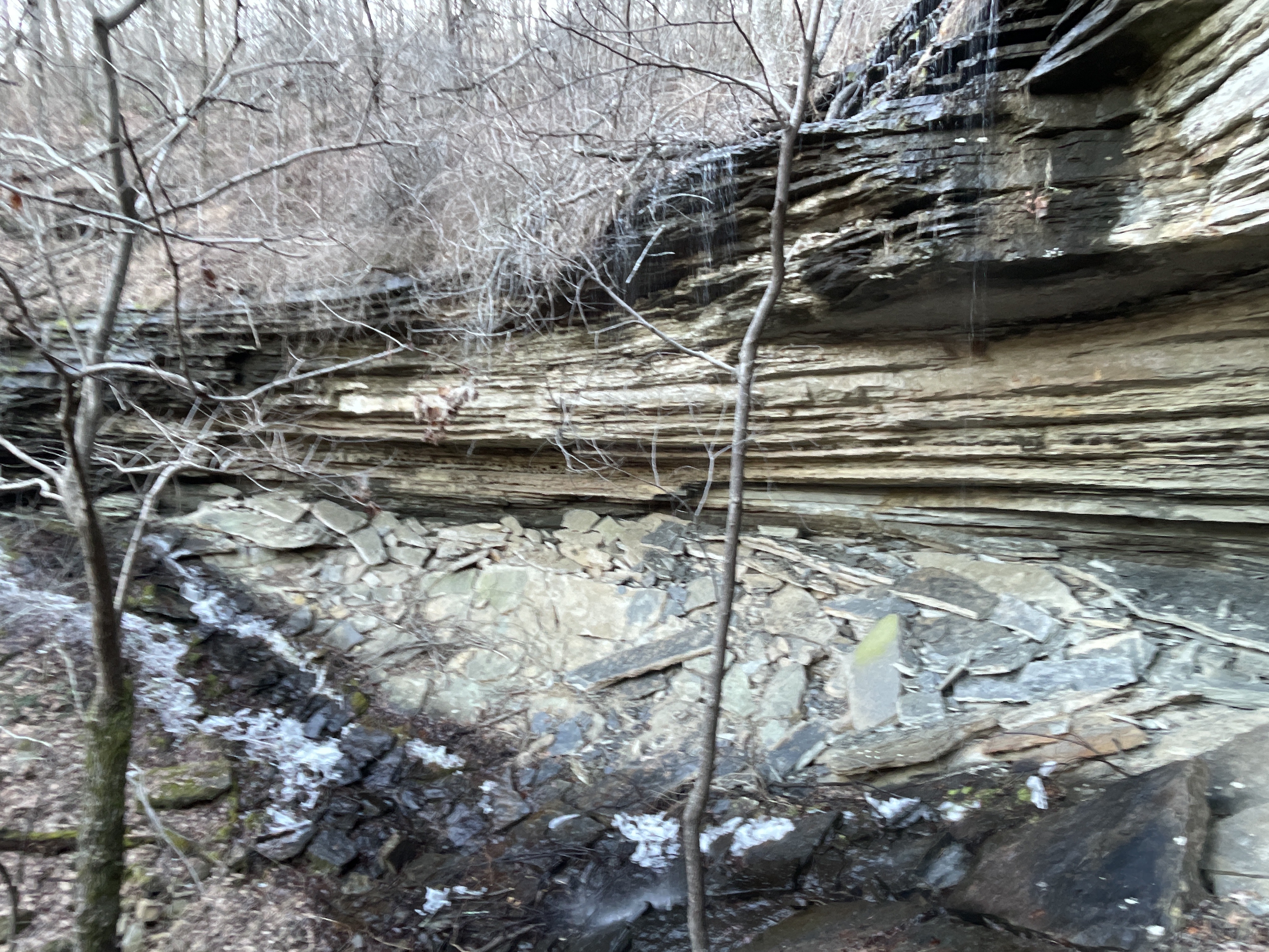
The parking area is North of the town of Harmony right along Hwy 103. From the parking area, I hiked just a little ways south on Hwy 103 and there is an atv road on the right across the street. I crossed the street and got onto the atv trail and hiked along that to the drainage. After I reached the drainage at waypoint 35.59564, -93.59137, I took a right and started bushwhacking up the drainage and hills to reach the bluffs. They are not that far up the hill from the atv trail. I reached the bluffs at waypoint 35.59747, -93.59369. I then took a right and hiked along the bluffs. There are many nice rock formations, features and shelters along these bluffs. There are a couple of places where water runs off the bluffs along there also. I kept hiking the along the bluff line checking out all the features until I reached Feature 25 (35.60505, -93.58743) and then I worked my way downhill to get below Spurton Falls. After I was done there, I kept working my way down the drainage and back to Hwy 103. I came across 3 more smaller waterfalls while working my way back down to Hwy 103. After I got back down to Hwy 103, I took a right and hiked back to my vehicle. It's a short hiked down the drainage back to Hwy 103. The yellow line on the maps is my track and the red line is Hwy 103
 |
| Shelter 3 |
 |
| Rock Formation 2 |
 |
| Shelter 3 |
 |
| Rock Formation 1 |
 |
| Feature 2 |
 |
| Shelter 1 |
 |
| Rock Formation 3 |
 |
| Feature |
 |
| Rock Formation 6 |
 |
| Shelter 8 |
 |
| Shelter 7 |
 |
| Feature 20 |
 |
| Spurton Falls |


No comments:
Post a Comment