2/2/2023 - Turner Hollow Waterfalls (WF) and Rock Formations
GPS Coordinates: (Latitude, Longitude)
Parking area: 35.62882, -93.61025
WF 1: 35.662337, -93.61413
Peak 1: 35.62367, -93.61644
Horse Hoof Arch: 35.62367, -93.61657
Feature 1: 35.62342, -93.61642
WF 2: 35.62322, -93.61512
WF 3: 35.62307, -93.61622
Cascade 1: 35.62302, -93.61667
Cascade 2: 35.62301, -93.61678
Cascade 3: 35.62297, -93.61728
Cascade 4: 35.62295, -93.61751
Cascade 5: 35.62309, -93.61752
Cascade 6: 35. 62267, -93.61779
WF 4: 35.62241, -93.61802
Cascade 7: 35.62213, -93.61864
WF 5: 35.62136, -93.62000
Cascade 8: 35.62155, -93.62001
Cascade 9: 35.62170, -93.62050
Niverney Falls: 35.62234, -93.62177
Waycona Falls: 35.62286, -93.62168
WF 8: 35.62069, -93.62023
Cascade 10: 35.61939, -93.62033
Cascade 11: 35.61881, -93.62019
Cascade 12: 35.61870, -93.62012
WF 9: 35.61859, -93.62003
Cascade 13: 35.61825, -93.61967
Cascade 14: 35.61547, -93.61601
WF 10: 35.61559, -93.61570
WF 11: 35.61578, -93.61539
Ehrman Falls: 35.61597, -93.61497
Horsehead Slate Falls: 35.61673, -93.61357
Rock Formation 1: 35.61703, -93.61407
Feature 2: 35.61700, -93.61426
Feature 3: 35.61696, -93.61496
Feature 4: 35.61688, -93.61543
Feature 5: 35.61685, -93.61567
Feature 6: 35.61704, -93.61622
Feature 7: 35.61737, -93.61655
Feature 8: 35.61831, -93.61683
Feature 9: 35.61912, -93.61621
WF 14: 35.61935, -93.61571
Rock Formation 2: 35.61928, -93.61612
Arch: 35. 61935, -93.61657
Shelter: 35.61941, -93.61699
Feature 10: 35.61947, -93.61740
Feature 11: 35.61942, -93.61766
Feature 12: 35.61948, -93.61772
Feature 13: 35.62022, -93.61833
Peak 2: 62056, -93.61798
WF 15: 35.62338, -93.61414
Markers:
Blue Waypoint = Named WF
Black Waypoint = Unnamed WF
Orange Waypoint = Cascade
Stone Symbol - Rock Formation
Shelter Symbol = Shelter
Car Symbol = Parking area
Running Person Symbol = Access Point
Backpacker Symbol = ATV trail
Peak Symbol = Peak/Overlook
Level of Difficulty: Hiking along the atv trail is easy. The hills here in the Horsehead Creek area have some of the steepest hills so they are strenuous going down them along the drainage and then up them along Turner Hollow. Hiking down in Horsehead creek is moderate to a little strenuous. There are downed tree's that you either have to climb over, go under or work your way around. There are the usual water crossings.
Hiking Statistics: 5.12 mile loop / Ascent is 814 ft / Descent is 833 ft /
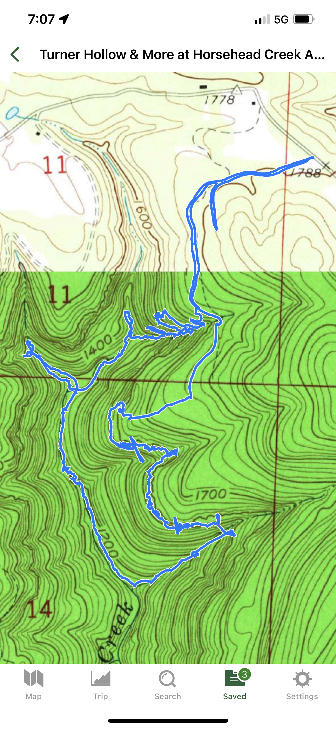
I took Hwy 103 south from Hwy 215. I took a right onto Rd 4160 from Hwy 103 and drove to the parking area along the road. I had hiked this area before but hiked it a totally different way so i already knew of a couple of the big falls there and had already named them. There is an old road across the street from the parking area. I crossed the street and got onto the old road and hiked that a ways. Eventually I came to a fork in the road. I could have went to the left and stayed up higher but I took the road to the right that went down lower that curved around. I kept an eye on my gps to see when I was getting close to the drainage I had planned on going down. When I got close, I left the gravel road and started bushwhacking down hill at coordinates 35.62389, -93.61492. I worked my to the access point to get below the bluff at coordinates 35.62350, -93.61515. After I got below, I followed the bluff to the left to reach wf 1. I took some photo's and marked it on my gps before moving on and hiking down the drainage. I soon came to the top of wf 2 and could see no way down by it. I hiked along the top of the bluff line to the right of the falls a ways and worked my my down hill to peak 1 at coordinates 35.62367, -93.61644. I spent some time there before finding a way down the hills to the right of the peak at coordinates 35.62374, -93.61646. I got below the bluff line and came to an arch called Horse Hoof Arch. I spent time there taking photo's and marking it. I then kept hiking along the bluff and came across another feature before getting back to the drainage where wf 2 was. After I was done there, I continued hiking down the drainage and soon came to the top of wf 3. Once again, I had to hike along the bluff to the right to find a way to get down below it. I found a way by coordinates 35.62329, -93.61686. These hills are steep and strenuous. I followed the bluff to the left to the drainage and to the bottom of wf 3. I was more than halfway down the drainage at this point. After I was done there, I continued hiking down the drainage and I was past the big bluffs so I was able to stay in the drainage the rest of the way down to Horsehead Creek. There were many downed tree's in the drainage that I either had to climb over, under or work my way around. I came across 6 cascades before reaching wf 4. I took photo's and marked them all on my gps. I soon was down in Horsehead Creek and I took a 15 minute break and sat down to enjoy the area. Turner Hollow was to the left but I wanted to explore to the right some so I headed that direction when I was done with my break. I first came across another 2 nice cascades and wf 5 before reaching 2 bigger wfs. A little ways further, I'd seen Niverney falls to my left and Waycona Falls a little further straight ahead. I first went up to the left to Niverney falls and took photo's and marked that before going back to Horsehead creek and continuing further to Waycona Falls. After I was done there, I decided to head back and work my way towards Turner Hollow. I quickly was back to the drainage that I had hiked down. While working my way from that drainage to Turner Hollow, I had come across 2 more wfs and 4 more cascades. I stopped and took photo's of them all and marked them all on my gps. I eventually reached Turner Hollow on the left and started hiking up it. I passed by another cascade and 2 more wfs before reaching the next big wf. I eventually reached Erhman Falls and took a break there as well as taking many photo's. The hills were getting steep at this time. While looking straight at the falls, I looked at the hills on both sides and decided to go up the hills to my left. I worked my way up the steep hills and then to the top of Erhman falls. I continued hiking up the hollow along the water. There are always water crossings in these drainages and hollows. I eventually reached Horsehead Slate Falls. I took another break there and enjoyed the area for awhile. I could see the bluffs and rock formations to my left up the hills as I was looking straight at the falls. When I was ready to get going, I worked my way up those steep hills to the bluffs and rock formations. I started hiking up the hills at coordinates 35.61667, -93.61377. After I got up to the first feature at coordinates 35.61703, -93.61407, I decide to forget about getting back into the hollow above the falls and to continue up that since I hiked all of it my first time there and to just continue hiking along the bluffs. I took the left and hiked along the bluffs that eventually curved to the right. I came across many nice features that I took photo's of and marked on my gps before I reached the next drainage where wf 14 is. There are other wfs down this drainage but the hills are very steep. During my first hike there, I hiked all the way down Turner Hollow and up this drainage back to the gravel road. Each set of hills I had to get up to be above the next falls in this drainage felt like I was climbing rather than hiking. On this hike, I went past wf 14 and continued hiking along the bluffs on the other side of the drainage. I passed by a shelter and many more features. I took many photo's and marked them all. I then looked at my gps to see where I was and could see that I was almost back to the drainage that I had originally hiked down. I wanted to find a way up above the bluffs on that side before reaching the bigger drainage. I found a place and started working my way up the steep hills at coordinates 35.62064, -93.61830. I worked my way up the hills to the access point at coordinates 35.62077, -93.61782. After I got to that point, I could see that I was above the bluff line so I hiked at that level to the right to see if there was an overlook and I soon got to peak 2. I spent some time there enjoying the view and taking a break after hiking up the steep hills. After I was ready to move on, I continued hiking up the hills and working my way back to the gravel road. I finally reached the gravel road at coordinates 35.62106, -93.61515. I then took a left onto the gravel road and followed that back out to the parking area. I was tired after this hike with how steep the hills are.
 |
| Horsehead Slate Falls |
 |
| Ehrman Falls |
 |
| Horse Hoof Arch |
 |
| Waycona Falls |
 |
| Niverney Falls |
 |
| Arch |
 |
| WF 2 |

 |
| Cascade 7 |
 |
| WF 4 |
 |
| Cascade 8 |
 |
| WF 7 |
 |
| Cascade 12 |
 |
| Feature |
 |
| Shelter 1 |
 |
| Feature |
 |
| Feature |
 |
| Rock formation |
 |
| Feature |
 |
| Shelter |
 |
| Shelter |
 |
| Feature |
 |
| Peak 2 |


No comments:
Post a Comment