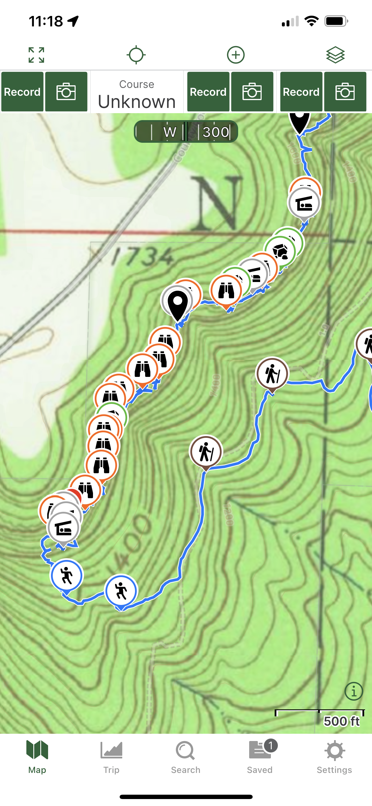
1/22/2023 - Chinquapin Ridge Bluffs (South)
GPS Coordinates: (Latitude, Longitude, Elevation)
Parking Area: 35.59246, -93.58435
Feature 1: 35.58771, -93.60029
Shelter 1: 35.58777, -93.60014
Carving in Rock: 35.58787, -93.59999
Feature 2: 35.58803, -93.59973
Feature 3: 35.58840, -93.59943
Feature 4: 35.58869, -93.59940
Feature 5: 35.58894, -93.59939
Feature 6: 35.58895, -93.59933
Rock Formation 1: 35.58912, -93.59924
Feature 7: 35.58941, -93.59927
Feature 8: 35.58955, -93.59911
Feature 9: 35.58986, -93.59867
Shelter 2: 35.59001, -93.59836
Feature 10: 35.59026, -93.59825
WF 1: 35.59087, -93.59801
Shelter 3: 35.59089, -93.59802
Feature 11: 35.59098, -93.59786
Feature 12: 35.59105, -93.59711
Rock Formation 2: 35.59117, -93.59694
Shelter 4: 35.59129, -93.59662
Feature 13: 35.59138, -93.59644
Rock Formation 3: 35.59163, -93.59611
Rock Formation 4 / Arch: 35.59175, -93.59597
Shelter 5: 35.59237, -93.59566
Feature 14: 35.59252, -93.59563
WF 2: 35.59369, -93.59575
Rock Formation 5: 35.59502, -93.59451
Rock Formation 6: 35.59518, -93.59451
Rock Formation 7: 35.59587, -93.59463
WF 3: 35.59635, -93.59474
WF 4: 35.59641, -93.59464
Feature 15: 35.59708, -93.59424
Feature 16: 35.59718, -93.59412
Markers
Black Waypoints = Unnamed WF's
Stone Symbol = Rock formations
Shelter Symbol = Shelters
Binoculars Symbol = Features
Backpacker Symbol = ATV Trail
Running Person Symbol = Access points
Car Symbol = Parking area
Level of Difficulty: The hike starts out moderate while your hiking along an atv most of the way to get to the bluffs. At a point, you have to start bushwhacking up hill to get to where the bluffs are. Hiking along the bluffs at times is moderate and at times can be strenuous depending on the size and steepness of the hillsides. You have to go up and down hills and along hillsides when following bluff lines. Hiking along the drainage back to the parking area is strenuous at first but then becomes more moderate the further you get down the hills to the parking area. This is a bushwhack while hiking along the bluff line and hiking along the drainage to get back to your vehicle.
Hiking Statistics for Loop: 3.74 miles / Ascent is 744 ft. and Descent is 744 ft.
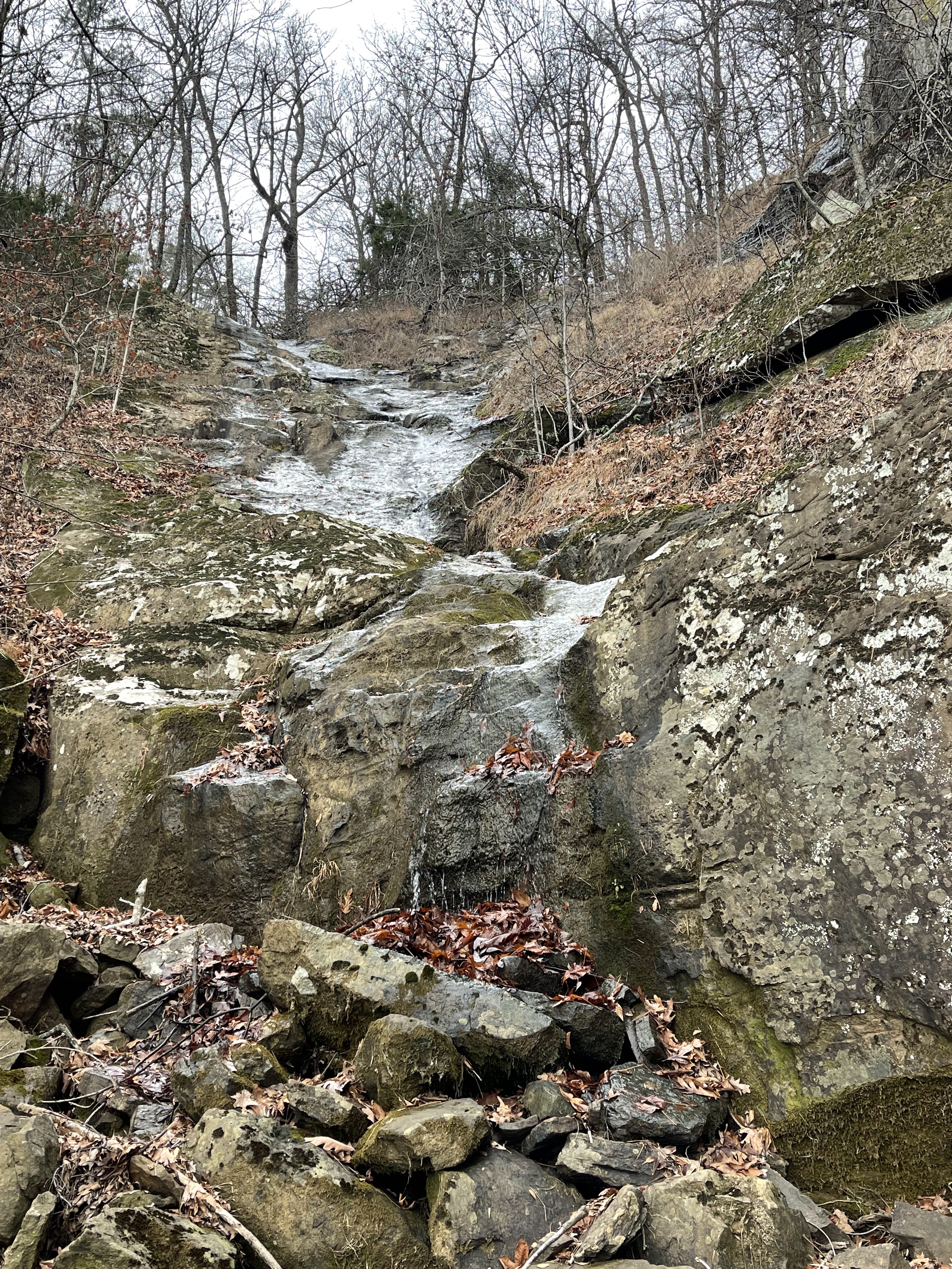
My friend joined me for this hike to explore this bluff area. We met along Hwy 103 with the parking area being right off Hwy 103. After we met, we drove to the parking area and I was planning to hike along the atv road as far up and as close the the bluff line as possible. There is a drainage that comes down right to the parking area so I told him that we can come back down to the vehicles along the drainage. The atv trail heads off to the left from the parking area so we started hiking along it. We came to some forks at times but I knew where I was aiming for along the bluffs so I kept along the road that would get us the closest to there. I marked 9 waypoints while hiking along the atv trail, which are the backpacker symbols. It gets harder to follow the further you get up. If you type in the 9 sets of coordinates on your gps, you should be able to follow the atv trail to where we did. They are (35.59266, -93.58503), (35.59251, -93.58596), (35.59064, -93.58660). (35.58823, -93.58862), (35.58935, -93.59126), (35.58903, -93.59386), (35.59023, -93.59441), (35.58979, -93.59625), (35.58861, -93.59749). We started bushwhacking a little ways after the last coordinates/backpacker symbol. I knew it was time to start heading uphill at coordinates 35.58650, -93.59906. We were still working our way up to the bluffs at coordinates 35.58674, -93.60008. We wanted to get up to the bluffs from the far left so that we could just take a right and hike along and below the bluffs in one direction from the left to the right. We reached the bluff line at coordinates 35.58762, -93.60050. We then started hiking along the bluffs and before we knew it, we came to a feature and then to a shelter right after it. This is a neat area because it has 2 shelters and then a tunnel connecting the 2 with a window to the tunnel. My friend didn't but I went in the first shelter and went through the tunnel and out from under the second shelter. My friend met me at the second shelter. We took a break and I took some photo's and I marked the shelter. When we were ready, we continued hiking along the bluff line. You are stuck having to go up and down hills constantly and along hillsides when hiking along bluff lines. While we were hiking along, we thought that there may be a shelter up the hill and around to our left so we hiked up the hill to see but it ended up not being much so we head back down to where we were hiking along. We came across 5 more nice features along the Bluffs before reaching the first Rock Formation. This rock formation is like an Arch. After that, we passed by 3 more nice features in the bluffs before reaching the next shelter. We spent some time in there and took photo's. We then kept hiking on along the bluff line and soon we came across the first waterfall that comes off of the bluff. There is a nice shelter there also behind the falls. After we were done there and continued on our way along the bluffs, we came across another nice feature in the bluff before we reached a crack that you can hike up and through between the bluff and another part that separated from it. We both went through the crack and out the other side. After that, we cam across another shelter. We both went in it and was looking and talking about how the rock formation was inside it. I took some photo's and then we were ready to continue hiking. We then came across another nice feature in the bluff and it looked like there was a shelter around the side again up the hill so we headed up to look but it wasn't much again so we headed back down and continue along the bluff line. We then reached another nice rock formation that is like an Arch. I took photo's from both sides since it looks different from both directions. After leaving that, we came across another shelter and decided to take a nice break by that shelter. After sitting and talking about the area and other things for around 20 mins, we were ready to continue on. While we continued hiking, we came across another nice feature in the bluff before we reached the next waterfall. This is where the gps shows a drainage so the bluff was not very tall and straight down. The rock was like at an angle so the water comes off the top and flows down the rock to the bottom. I'm sure it is nice when it is fully running. After I took photo's there, we kept hiking along and came across a nice rock formation standing by itself. I took photo's from both sides of it. We then continued on and came to where the bluff sticks out and you can go under it and out the other side. I climbed up part of it and had my friend take a photo of me up there. After we were done there, we came across 2 more waterfalls when water is running good. Water was not running good that day we hiked there. After I marked those and took a couple of photo's, we kept hiking along the bluff and came across 2 more nice features in the bluff. I then looked at my gps and could see that we were just about at the drainage that goes down right by the parking area. We had planned to hike back down along that so we crossed to the other side of the drainage and then started heading downhill along the drainage at coordinates 35.59756, -93.59349. We followed that all the way down and came across another WF in the drainage while working our way down. We left the drainage at coordinates 35.59380, -93.58623 and heading straight for the parking area. We had been hiking for over 4 hours when we arrived back at the parking area.
 |
| Shelter |
 |
| Tunnel |
 |
| Shelter |
 |
| Shelter |
 |
| Shelter |

 |
| Arch |
 |
| Shelter |
 |
| Feature |
 |
| WF |
 |
| Feature |
 |
| Feature |
 |
| WF |
 |
| Feature |
 |
| Arch |
 |
| Shelter |
 |
| WF |
 |
| Rock Formation |
 |
| Rock Formation |
 |
| Feature |
 |
| Shelter |
 |
| My Track |


No comments:
Post a Comment