1/15/2023 - Reeves Point Bluffs & More
GPS Coordinates: (Latitude, Longitude, Elevation)
Parking area 1 / Campsite: 35.74150, -93.27247
Parking area 2 / Campsite: 35.76014, -93.27886
Hanging Tree 1863: 35.76345, -93.27803
Rock Formation 1: 35.76335, -93.27772
Rock Formation 2: 35.76297, -93.27639
Arch: 35.76300, -93.27134
Feature 2: 35.76309, -93.27095
Feature 3: 35.76276, -93.27066
Feature 4: 35.76251, -93.27029
Feature 5: 35.76178, -93.26978
Shelter 1: 35.76152, -93.26967
WF 1: 35.76145, -93.26951
Shelter 2: 35.76152, -93.26938
Feature 6: 35.76171, -93.26907
Feature 7: 35.76178, -93.26896
Feature 8: 35.76204, -93.26898
WF 2: 35.76204, -93.26810
Feature 9: 35. 76232, -93.26747
Feature 10: 35.76248, -93.26760
WF 3: 35.76293, -93.26740
WF 4: 35.76262, -93.26687
Reeves Point Falls: 35.76232, -93.26674
Feature 11: 35.76217, -93.26703
Feature 12: 76260, -93.26637
Feature 13: 35.76274, -93.26646
Feature 14: 35.76314, -93.26653
Feature 15: 35.76352, -93.26673
Shelter 3: 35.76416, -93.26709
Feature 16: 35.76438, -93.26703
Feature 17: 35.76507, -93.26713
Rock Formation 3: 35.76542, -93.26722
Feature 18: 35.76578, -93.26672
Rock Formation 4: 35.76571, -93.26649
Lonely Falls: 35.76585, -93.26678
Feature 19: 35.76637, -93.26684
Feature 20: 35.76703, -93.26718
Feature 21: 35.76703, -93.26737
Feature 22: 35.76703, -93.26754
Rock Formation 5: 35.76806, -93.26818
Feature 23: 35.76813, -93.26805
Feature 24: 35.76844, -93.26825
Feature 25: 35.76902, -93.26901
Shelter 4: 35.76924, -93.26961
Feature 26: 35.76941, -93.26978
Feature 27: 35.76947, -93.26994
Cascade 1: 35.76578, -93.27118
Markers
Blue Waypoint = Named WF
Black Waypoint = Unnamed WF
Orange Waypoint = Cascade
Binoculars Symbol = Feature
Stone Symbol = Rock formation
Backpacker Symbol = Gravel road, old road and atv trail
Shelter Symbol = Shelter
Car Symbol = Parking area
Running Person Symbol = Access point
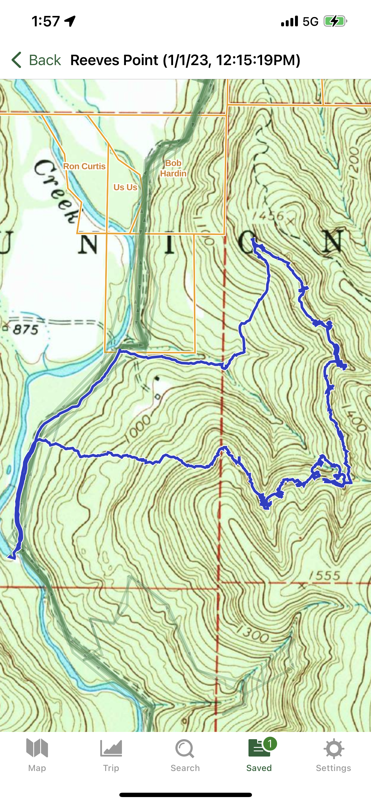
Level of Difficulty: This is a bushwhack hike mostly. There is no trail. The hike up to the bluff line is moderate. The hills are not that steep and you do not have to hike all the way up to the top of the hills. Hiking along the bluff is also moderate with the usual up and down hills that you have to go up and down. At time, you have to hike along the hillsides which is the toughest part of the hike. The hike downhill back to the gravel road is moderate also. The hike along the gravel road is easy.
Hiking Statistics for Loop: 3.69 miles / Ascent is 651 ft. and Descent is 662 ft.
We took Parker Ridge Rd which is a gravel road down to where the Rock Creek area is in Tim Ernst's waterfall book from the town of Deer, AR. You eventually have to take the road to the right which is a rougher gravel road just before you reach the bridge that crosses over The Big Piney Creek. Parking area 1 is just before that road crosses Rock Creek. There is a campsite there and many rock climbers park there. If you have a high clearance vehicle and feel comfortable driving through Rock creek or you have a 4 wheel drive vehicle, you can go through it and park at Parking area 2. If you have to park at Parking area 1, your hike will be 3.5 miles longer. Those 3.5 miles will be along the gravel road. Parking area 2 is right along The Big Piney and there is a campsite there also. We parked at parking area 2 and hiked from there. This is mostly a bushwhack / off trail hike except for when your hiking on the gravel road. There are waterfalls along this hike but we need a good amount of rain to heavy rain for them to be running good and some to be running at all. The falls were not running that good that day and some were not running at all. We started hiking to our left from the parking area along the gravel road. A ways down the road, we'd seen an open area to our right and that a tree had a marking in it. We went to it and seen the marking carved into it says "Hanging Tree 863". We decided to start heading up hill from there. We passed by a couple of rock formations while working our way up the hills. We also came across a couple of very old roads while we continued to work our way up to the bluff line. We reached the bluff line at coordinates 35.76259, -93.27176 and then we started following the bluff line to the left. We first came across a nice Arch. We took some photo's and then kept hiking along the bluff. We passed by 4 more nice features after we left the arch. We could see on our gps that we were getting close to a drainage so I was thinking there may be a WF off the bluff there. We came to a nice shelter and took a snack break there. When we left there, we then came across the first WF. I took some photo's and then we hiked some and came across shelter 2 very soon. After we left the second shelter, we could see some features up the hill to our right so we went uphill some to see those. When we were done up there, we went back downhill and kept working our way to the right along the bluff. We came across another feature before reaching WF 2. These waterfalls need a lot of rain to be running. As we were working our way along the bluff, we seen another couple of feature up to our right so we headed up to those and then back down to continue along the bluff. WE were coming to one of the bigger drainages now that intersects with the bluff line. We could hear a little water running so we headed down hill at an angle to the left and we reached WF 3. After I took a couple of photo's, we kept heading up the drainage towards the bluff and we came across WF 4.Then we kept working our way up the drainage to where we were right along the bluff again. We were on the left side of the drainage but I had to go check the right side just under the bluff to see if a WF was there and that is where Reeves Point Falls is. I told my friend to come over and he did to the falls.. I climbed up above that to go see another feature and then climbed back down below Reeves Point falls. When we were done there, we continued to the other side of the drainage where we were first and along the bluff line. We are below the bluffs here most of the time. We came across another 4 nice features while working our way along the bluffs. We are hiking up and down hills and at times along the hillside here while working our way along the bluff line. We then came across shelter 3. You can't just walk in it, you have to get down low and then you can stand up inside. You can go in one and out another but you have to be on your knees to get in and out of both. We spent some time there and took another break. When we were done there, we continued hiking along the bluff line. We came across another 2 nice features before reaching rock formation 3. I could see that there was another WF past that but also could see some features above that rock formation to my right so I climbed up and went above the bluff line to another nice rock formation up there. I passed by another feature while working my way to be back down below the bluff. It is not a tall bluff at this point so it was not hard to get up above it and back down. My friend decided to wait for me down there though while I climbed up and back down. He waited for me by the WF. When I got back down below the bluff, I continued to the right along the bluff to Lonely falls where my friend was waiting for me. Lonely falls is a nice waterfalls and the bluffs curves around in a nice way where your partially under the bluff for a ways. We then came across another feature. A little ways after that, we'd seen a feature up to our right so we went up the hill just a little ways to that and then back down. We kept working our way along the bluff line and then came to 2 more features. A ways along the bluff line and hillside, we came across another rock formation and 2 more features. After that, we came across another nice feature before reaching Shelter 4. We spent some time there and then kept working our way and came across 2 more nice features. I then looked at my gps to see where we were and we decided it was time to head back down to the gravel road. We kept heading downhill at an angle to our left to get back into that bigger drainage we were at the tip of earlier by the bluff where we'd seen those 2 WF's and Reeves Point falls. When we got back to that, we took a right and were following that drainage back down to the gravel road. When we reached that drainage, we were already more than halfway down the hill back to the gravel road. The very low part of that drainage that flows into the Big Piney and goes through the road is on private property so we had to cross over the drainage and go uphill to the left a little and hike the hillside to to where we could finish going downhill to get back on the gravel road and skip the private property. Once we got back onto the gravel road, we took a left and hiked along it back to the parking area. The views of the Big Piney there at the parking area are beautiful. I took photo's of it there and we spent some time there relaxing by it before we drove off and headed back to my friends house.
 |
| Shelter 1 |
 |
| Arch |
 |
| Crevice |
 |
| Feature |
 |
| Shelter 2 |
 |
| WF 1 |
 |
| Feature |

 |
| WF 4 |
 |
| Feature |
 |
| Reeves Point Falls |
 |
| Feature |
 |
| Shelter 3 |
 |
| Lonely Falls |
 |
| Feature |
 |
| Rock Formation 4 |
 |
| Feature |
 |
| Feature |
 |
| Shelter 4 |
 |
| Feature |
 |
| Feature |
 |
| Cascade |
 |
| WF 2 |
 |
| WF 3 |
 |
| Parking area 2 |

 |
| Big Piney |
 |
| Big Piney |
 |
| My Track |
 |
| Track with Waypoints |
 |
| Part of track |
 |
| Part of track |
 |
| Part of track |
 |
| Part of track |
 |
| Part of track |


No comments:
Post a Comment