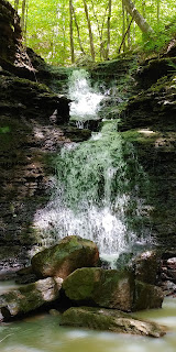
2/27/2019 - Clifty Hollow Waterfalls (WF)
GPS Coordinates - (Latitude, Longitude, Elevation)
Parking Area A: 35.71678, -93.40716
Parking Area B: 35.68773, -93.41118
Clifty Hollow falls: 35.71161, -93.40750
WF 2: 35.71042, -93.40780
WF 3: 35.71029, -93.40849
Tapered Grotto Falls: 35.70873, -93.40820
WF 5: 35.70730, -93.40739
WF 6:35.70636, -93.40732
WF 7: 35.70584, -93.40728
Stumble falls: 35.70546, -93.40972
Tumble falls: 35.70658, -93.40970
Clifty Cascade: 35.70470, -93.40815
WF 11: 35.70300, -93.40642
WF 12: 35.70194, -93.40728
WF 13: 35.70171, -93.40732
WF 14: 35.70158, -93.40668
WF 15: 35.70147, -93.40661
Other Gravel road if hiking the loop: 35.70173, -93.40004
Markers:
Blue waypoints are Named waterfalls
Black waypoints are Unnamed waterfalls
Backpacker icon is the parking areas
Level of Difficulty: Strenuous at the top due to the brush but there is less as you get further down the hills and it becomes Moderate. You can hike down from the top and then cut up to the rougher road like I did on my map and then hike along that road back to CR#5570. If You have multiple vehicles, CR#5550 is down at the bottom of the hollow so you can park at both ends.
Hiking statistics for Loop: 3.66 miles / Highest to Lowest elevation difference is 749 ft
Hiking statistics for one-way hike:
When you start at the top, the hills can be a little steep with much brush but get easier as you get further down the hollow with much less brush.. If you hike all the way to the bottom where parking area B is, the second half of the hike is pretty level. If you hike the loop, you will eventually have to head up hill to a gravel road and then up hill on that road back to CR# 5570
CR 5570 is off of Hwy 21 north of the Ozone Rec Area. It goes east from hwy 21. Turn onto that road and drive to parking area A. If you are hiking the loop, this is the parking area to use. If you are with others and have at least 2 vehicles, you can park another vehicle at parking area B, which is along CR 5550. CR 5550 is off of Hwy 21 also. My friend and I once left my car at the bottom at parking area B and we went in his car to parking area A and started our hike there at the top. From parking area A, head down the hill to the water. If you are using a GPS, you should see where the water is on it. Follow the hollow downstream to the waterfalls. You will first come to Clifty Hollow falls. After I'm done there, I keep working my way down the hollow and will come across 2 others waterfalls. The next waterfall you come across down the hollow will be Tapered Grotto falls after the 2 smaller waterfalls. This is a really cool waterfall. The top is wide but the way the rock is tapered and much more narrow when down below makes you think about how water over time formed that. I still have not been there yet when at least 3/4 of the creek at the top of that falls is full of water. Water would be running down the sides also of the opening. After I'm done enjoying this beautiful spot, I continue heading down the hollow. You will pass by 3 other waterfalls before you come to a drainage on your right at 35.70550, -93.40776 that has 2 waterfalls up that a little ways. The coordinates have been provided to Nucentric & Stumble falls. After I am done there, I head back to the main hollow and take a right to continue heading downstream. You will come across Clifty cascade just a little ways down the hollow from the drainage. After you leave Clifty Cascade, you will see a waterfall to your left up the hill a little ways. Then, as you work your way down the hollow, you will see 2 more waterfalls in the main hollow. Just a little ways down from those 2 waterfalls, you will see 2 more to your left up the hill a little ways at 35.70176, -93.40664. If you are hiking the loop, work your way up to the top of this waterfall and keep working your way up the hill to the gravel road at 35.70173, -93.40004. Then take a left and hike back up to CR 5570. Once you reach CR 5570, take a left back to your vehicle. If you are planning to finish your hike at parking area B, then head back down into the hollow and keep heading downstream. Along this part is pretty level and a beautiful walk in the woods along the creek. You will eventually reach CR 5550 that crosses Clifty Hollow. Parking area B is to your right.
 |
| Tapered Grotto falls from the Top |
 |
| Tapered Grotto falls |
 |
| Clifty Cascade |
 |
| Tumble falls |
 |
| Stumble falls |


No comments:
Post a Comment