2/26/23 - Gobblers Knob Hollow Waterfalls (WF)
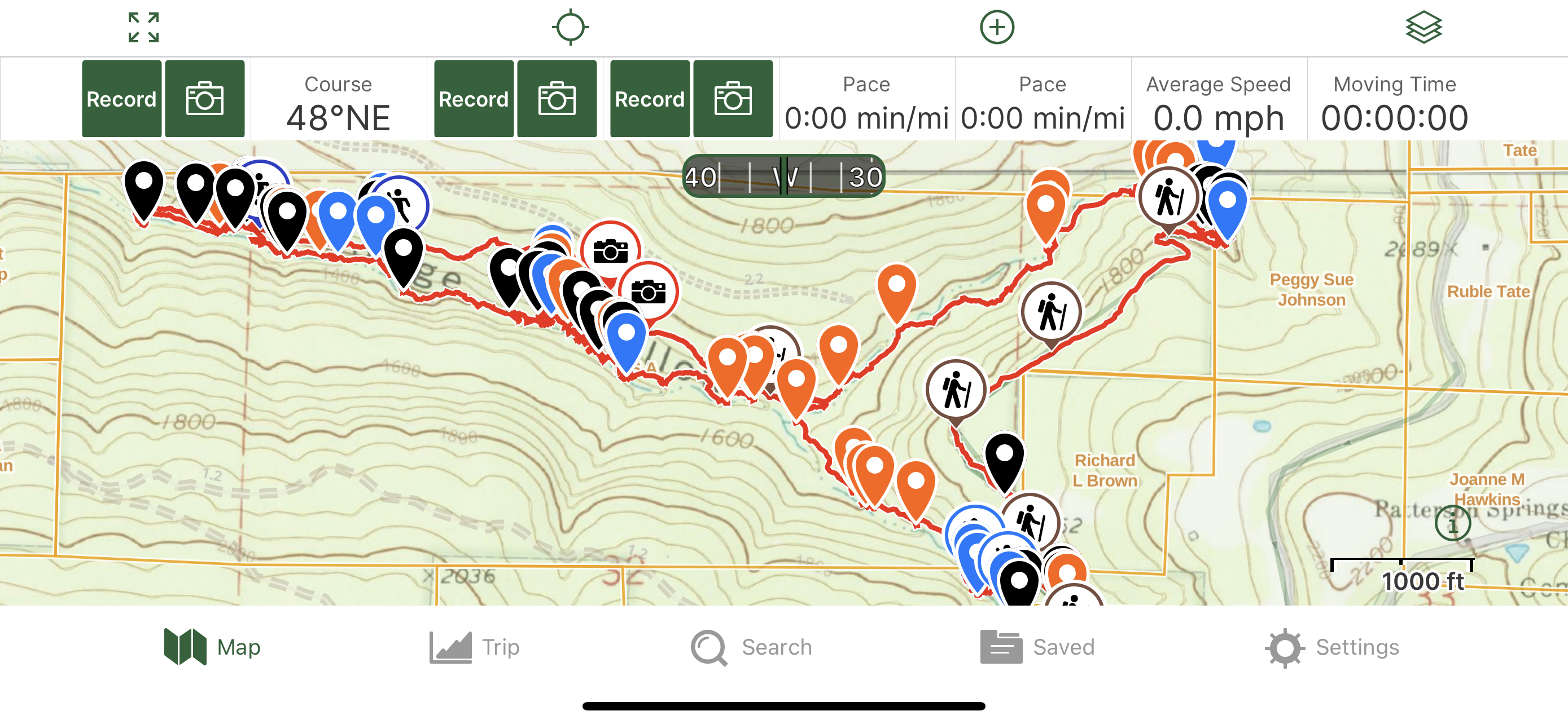
GPS Coordinates: (Latitude, Longitude, Elevation)
Parking area: 35.76498, -93.36602
Cascade 1: 35.76766, -93.36435
Cascade 2: 35.76787, -93.36436
WF 1: 35.76806, -93.36441
Cascade 3: 35.76861, -93.36463
WF 2: 35.76864, -93.36472
WF 3: 35.76873, -93.36474
Cascade 4: 35.76943, -93.36528
Cascade 5: 35.76972, -93.36566
Cascade 6: 35.77020, -93.36566
Cascade 7: 35.77095, -93.36629
Cascade 8: 35.77134, -93.36679
WF 4: 35.77144, -93.36661
Cascade 9: 35.77168, -93.36644
Cascade 10: 35.77199, -93.36659
Cascade 11: 35.77243, -93.36647
Cascade 12: 35.77283, -93.36647
Cascade 13: 35.77329, -93.36656
WF 5: 35.77362, -93.36653
Gobblers Knob Grotto Falls: 35.77376, -93.36680
Cascade 14: 35.77380, -93.36666
The Moss Slot: 35.77400, -93.36675
Good Sheppard's Falls: 35.77415, -93.36688
Rock Feature 1: 35.77436, -93.36668
WF 8: 35.77475, -93.36656
WF 9: 35.77496, -93.36645
Rock Feature 2: 35.77517, -93.36649
WF 10: 35.77539, -93.36650
Cascade 15: 35.77532, -93.36686
WF 11: 35.77512, -93.36712
WF 12: 35.77485, -93.36675
Cascade 16: 35.77599, -93.36691
WF 13: 35.77675, -93.36713
Cascade 17: 35.77700, -93.36702
WF 14: 35.77728, -93.36703
Cascade 18: 35.77761, -93.36716
Cascade 19: 35.77771, -93.36728
Cascade 20: 35.77786, -93.36729
WF 15: 35.77801, -93.36740
WF 16: 35.77820, -93.36723
WF 17: 35.77838, -93.36728
WF 18: 35.77861, -93.36748
Rock Feature 3: 35.77884, -93.36733
Rock Feature 4: 35.77941, -93.36733
Cascade 21: 35.77963, -93.36745
WF 19: 35.78064, -93.36749
Cascade 22: 35.77997, -93.36999
Cascade 23: 35.77962, -93.37028
Cascade 24: 35.77936, -93.37050
WF 20: 35.77885, -93.37079
Cascade 25: 35.77871, -93.37096
WF 21: 35.77797, -93.37213
Cascade 26: 35.77787, -93.37210
WF 22: 35.77096, -93.36714
Overhang Bluff Falls: 35.77107, -93.36715
Markers
Blue Waypoint = Named WF
Black Waypoint = Unnamed WF
Orange Waypoint = Cascade
Hiker symbol = ATV trail
Running Person symbol = Access point
Stone symbol = Rock Feature
Car Symbol = Parking area
Level of Difficulty: There is no trail. This is a bushwhack hike. Going up the first hill from the gravel road was moderate. Up along the top was mostly easy with the terrain being level and the first couple of hills going down hill was moderate. When I got about halfway down to the hollow, the hills started getting steeper and the hike became strenuous. Hiking along and in Gobblers Knob hollow and the drainage can be strenuous with many tree's being down that you either have to climb over or hike up hills and then down to get around. I crossed the water many times and had to hike up hills from the top of a waterfall and then along the hillside to find a way down below the waterfall. Going up the hill to cut over to the other drainage from Gobblers Know hollow was strenuous some. Hiking up that drainage was similar to hiking down Gobblers Knob hollow. Hiking along the atv trail was easy. The first half of hiking up the hills from the atv trail was strenuous with the hills being steep but the second half was more moderate with those hills being more gradual.
Hiking Statistics for Loop: 3.82 miles / Ascent is 925 feet and Descent is 886 feet
To get to the parking area, I took Hwy 21 to CR # 5570. I drove along CR # 5570 east to CR# 7549. I took a left onto that road and drove to the parking area. On most of my hikes, I have to hike down hill first but on this hike, I had to hike up hill just a little ways first where Gobblers Knob is to be able to get to the other side of the mountain from the road in order to hike down to the hollow. After I was at the top, I looked at my gps to see witch way to go to get to the hollow. I hiked at an angle to the right down hill and into the hollow. I was in the hollow just at the tip of it at coordinates 35.76671, -93.36414. The hills were moderate to get where I was since I was just at the tip of the hollow. As I started working my way down the hollow, the hills on the sides became steeper so I was glad that I went down the less steep hills to be in the hollow. As I was hiking down the hollow, I came across 2 cascades that I stopped and took photo's of. Water was not running as good as I was hoping that it would be. Just a little ways further down the hollow, I was at the top of WF 1. I hiked up the hill to the right of the top of the falls and hiked along the hill side a little ways to coordinates 35.76814, -93.36430. I headed down hill to get below and in front of the falls at those coordinates. Where I went down would have been like a cascade WF with steps if water had been running better. I had to sit down and drop down to get down the last part. I spent some time there taking photo's and marking the falls on my gps. When I was done there, I continued hiking down the hollow. The hike is starting to get tougher now with many tree's being down and having to either climb over and under them or hike up and down hills to get around them. I came across another nice cascade that was running some as I was working my way down the hollow. Just a little ways after that, I came across 2 small WF's. I was still not in the big part of the hollow that the gps showed on my map yet. I spent some time there taking photo's of both falls. I continued on down the hollow after that and came across another nice cascade. Now I'm getting into the main hollow that is shown on the gps. I came across 5 cascades as I was working my way down. Very soon after those, I reached a small WF. I took some photo's and marked it on my gps before moving on. I was hoping to reach another WF soon with the hills getting steeper on the sides and being in the main hollow now. I ended up coming across 5 more cascades while working my way down the hollow first. Finally, I reached a WF to my left that would be running good after heavy rain. I took photo's and marked it on my gps before moving on. I then came to where there was a small falls to my right and a narrow steep drop off in the main hollow. I took some photo's from the top of it and then looked at both hillsides to decide which one to use to get down below. I was on the right side of the water but crossed over to the left to get a better look at the hillside on the right. I decided that the right side was the better hillside and had hills that I could see that I could use to get down below the bluff. I crossed back over and headed up hill to coordinates 35.77383, -93.36650. After I reached that point, I started heading down hill and used the hill at coordinates 53.77393, -93.36670 to get below. As I worked my way down the hill and to the left, I could see Gobblers Knob Grotto Falls and how nice the grotto looked. I started video taping as I was hiking down the hill and getting closer to the falls. I looked to my right and seen how the bluff went all along the hollow across the way making a long slot area that has moss all over on the other side. I could also see another waterfall coming off the bluff on the other side down along the slot a ways. I got down in front of the falls and took many photo's and a couple of videos. I spent at least 20 minutes taking pictures around Gobblers Knob Grotto falls. I then started walking along tight areas along parts of the rock in the slot area and worked my way carefully to where I was close to the other WF coming off the bluff. I knew if water had been higher, I would have had to have just walked through the water to be where I was in the slot or if water had been too high, I would not even be able to be down there. I marked Good Sheppard's Falls on my gps and debated about trying to go further down the slot passed this falls but it looked like it just got too tight. I decided that I would have to go back a certain ways until I found a way to climb back up along the hillside I was on when I originally came down but I knew that I didn't have to go back up as high as where I was when I first came down. I video taped me hiking back through the slot towards Gobblers Knob Grotto Falls. I also took many photo's before climbing up to get back on the hillside. After I got up, I hiked along the hillside where I was just above the hollow and could see Good Sheppard's Falls just across the way from me. I took some photo's and a video of it from up there. When I was done there, I continued hiking along the hillside and could quickly see a neat bluff up the hill to my right a little ways. I decided to go up there and check that out first and then work on finding a way back down into the hollow where I was right next to the water. There is a nice long bluff there that a has a couple of good size / long shelters that you can take breaks under or even camp under. There were 2 WF's between the 2 shelters coming off that bluff and then one other WF after the second shelter. I took photo's of all those and marked them on my gps. After the third WF, I was getting close to the end of the bluff so I decided to start heading back to the hollow and work my way down into it. I started heading down hill towards the water at coordinates 35.77550, -93.36653. After I was back down right by the water, I worked my way up stream as far as I could to where I was on the other side of that tight area that I would not have gotten through without getting soaking wet. There was a WF on my left coming off the bluff as I was working my way up the hollow to that tight area. I could see now that what I was thinking from the other side was correct. I would have been totally soaked if I had tried to go all the way through the slot area. I took some photo's of that area and turned around and started hiking downstream along the hollow. I came across a WF to my right before reaching a couple of nice cascades in the hollow. The hollow was like a narrow canal now so I had to be up the hill on the right side some now and would hike up along there and then would have to hike down hill to get close to the water every time I came to another nice cascade or small WF and then back up hill. There were 4 nice cascades and 6 nice WF's in and along this canal so I kept going down to take photo's and marking them on my gps and then hiking back up hill some to continue on. I was finally able to get lower and closer to the water and came across 2 neat rock formations by the hollow. I took photo's of them and marked them. I looked at my gps and could see that I was getting close to the private property and it would soon be time to head up the hills to me left and cut over to the drainage that I was planning to hike along going back up. I decided to take a 15 min break by the second rock formation to get some food in me, some liquids in me and just to enjoy the area. When I was done with my break, I continued on hiking down the hollow. I came across 2 more nice cascades in the hollow. I crossed over to the left side just before I reached the first of the two cascades. After I left those, I then reached a nice waterfall that had small bluffs on both sides and a big pool so I had to go a ways along the hill on the left side to find a way to get down in front of the falls. I finally found a way down and took photo's and marked it on my gps. I then looked at my gps. After I was done there, I headed back up the hill I had gone down and knew that it was just about time to start hiking up the hills to my left and as I was hiking, I could see the big red dot on the tree a certain distance ahead of me. I decided to start hiking up hill then. I started hiking up hill at coordinates 35.78098, -93.36738. and worked my way up hill at an angle to where I was at coordinates 35.78091, -93.36855. I had to hike at an angle up the hill also to miss the private property. I started hiking down hill at an angle at the previous coordinates to get down and into the drainage. After I got down into the drainage by the water, I took a 10 min break. I was planning on hiking up this drainage most of the way but I knew that I could not go all the way up it due to private property at the top of it. As I was hiking up the drainage, I came across 3 cascades before reaching a WF. I took photo's of the cascades and the WF as well as marking them all on my gps. When I was done at the WF, I continued hiking up the drainage. Just like in Gobbler Knob Hollow, there were downed tree's that I had to climb over or hike up and down hills to get around. The hills on the side of the drainage were steeper in the lower half of this drainage. As I was working my way up along the drainage as well as up and down some hills, I came across 2 more cascades and another WF. I took photo's of them and then continued hiking. I had a rout drawn and still had a decent ways to go up the drainage before I was going to cut over to the left and back where I was earlier but I reached at atv trail at coordinates 35.77653, -93.37317 and decided to just hike along that back to Gobblers Knob hollow. I hiked along the atv trail for awhile and then could hear water running good down to my left. I was wondering if that was new or had I'd seen it when I was down lower but I could see that they were new to me so when I got closer I headed down to WF 22. I took photo's and marked it on my gps. Then I could see I was close to the top of another WF. I had to work my way back up the hill to the left and then around the right to get down below the next WF. I worked my way down below it at coordinates 35.77114, -93.36721. This WF has a big boulder partially in front of it with an overhang that sticks out far on the other side of it. It is called Overhang Bluff falls. I spent some time there taking photo's and a video as well as marking it on my gps. I then decided to go a little further down the drainage to see if there was more and then I got to the point where I was just up the hill from the top of a smaller falls that I was just below earlier while working my way down Gobblers Knob hollow. I knew I had gotten that falls earlier from below so I just headed back up hill to Overhang Bluff falls and worked my way up the hill from there that I had used to get down there and went back to the atv trail. After I got back onto the atv trail, I took a left and continued hiking along that. I kept looking at my gps to decide how close I wanted to get to the hollow where my track was before I started bushwhacking up hill to get back up to the top. I got off the atv trail and started bushwhacking up hill at coordinates 35.76915, -93.36529. I ended up hiking up steeper hills than what I hiked down at the beginning of the hike but I just didn't feel like dealing with the downed tree's along the water again. I worked my way up the hills to coordinates 35.76632, -93.36608 where the terrain is level. From there, I hiked at that level for a little bit before heading down hill and back to the gravel road where my car was parked.
 |
| Gobblers Knob Grotto Falls |
 |
| Cascade 11 |
 |
| The Slot from a distance |
 |
| Inside The Slot |
 |
| Good Sheppard's Falls |
 |
| WF 8 |
 |
| Shelter below long bluff |
 |
| WF 9 |
 |
| WF 10 |
 |
| Cascade 2 |
 |
| WF 1 |
 |
| Gobblers Knob Grotto Falls |
 |
| Gobblers Knob Grotto Falls |
 |
| Tight space that I could not get through |
 |
| Cascade 16 |
 |
| WF 13 |
.jpg) |
| Part of canal |
 |
| Cascade 15 |
 |
| Cascade 14 |
 |
| WF 19 |
 |
| Overhang Bluff Falls |
 |
| Overhang Bluff Falls |
 |
| WF 22 |
 |
| Old Atv trail |

 |
| Parking area |
 |
| the level terrain after I got up to the top of the hills |